
Country United States County Smith FIPS code 20-39100 Area 82 ha Zip code 66952 Local time Tuesday 9:51 AM | Time zone Central (CST) (UTC-6) GNIS feature ID 0471973 Elevation 562 m Population 206 (2013) Area code 785 | |
 | ||
Weather -6°C, Wind E at 18 km/h, 80% Humidity | ||
How to say or pronounce usa cities lebanon kansas
Lebanon is a city in Smith County, Kansas, United States, in the north central part of the state. As of the 2010 census, the city population was 218.
Contents
- How to say or pronounce usa cities lebanon kansas
- Map of Lebanon KS 66952 USA
- History
- Geography
- Area attractions
- 2010 census
- 2000 census
- Rural flight
- Government
- Education
- Media
- References
Map of Lebanon, KS 66952, USA
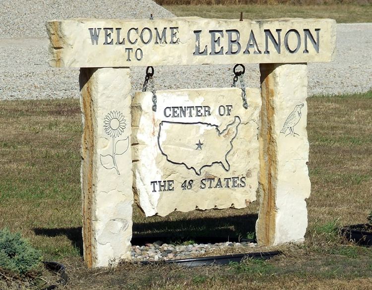
In 1918, a scientific survey established the geographic center of the 48 contiguous U.S. states about 2.6 miles (4.2 km) northwest of Lebanon, and a monument was subsequently erected at the site. The geographic center of the 50 U.S. states is located near Belle Fourche, South Dakota.
History
Lebanon was founded in 1876 at a site about 4 miles (6.4 km) distant from its present site. It was moved to the new site in about 1887-1888. Lebanon is named after Lebanon, Kentucky.
Geography
Lebanon is located at 39°48′38″N 98°33′22″W (39.810492, -98.556061). According to the United States Census Bureau, the city has a total area of 0.316 square miles (0.818 km2), all land.
Area attractions
2010 census
As of the census of 2010, there were 218 people, 118 households, and 60 families residing in the city. The population density was 681.3 inhabitants per square mile (263.1/km2). There were 183 housing units at an average density of 571.9 per square mile (220.8/km2). The racial makeup of the city was 95.9% White, 0.5% Native American, 0.5% Asian, and 3.2% from two or more races. Hispanic or Latino of any race were 3.2% of the population.
There were 118 households of which 16.9% had children under the age of 18 living with them, 42.4% were married couples living together, 4.2% had a female householder with no husband present, 4.2% had a male householder with no wife present, and 49.2% were non-families. 46.6% of all households were made up of individuals and 22.9% had someone living alone who was 65 years of age or older. The average household size was 1.85 and the average family size was 2.62.
The median age in the city was 51.3 years. 17.4% of residents were under the age of 18; 2.8% were between the ages of 18 and 24; 14.8% were from 25 to 44; 40.8% were from 45 to 64; and 24.3% were 65 years of age or older. The gender makeup of the city was 48.2% male and 51.8% female.
2000 census
As of the census of 2000, there were 303 people, 151 households, and 91 families residing in the city. The population density was 955.5 people per square mile (365.6/km²). There were 204 housing units at an average density of 643.3 per square mile (246.1/km²). The racial makeup of the city was 99.01% White, 0.33% Native American, and 0.66% from two or more races. Hispanic or Latino of any race were 1.32% of the population.
There were 151 households out of which 15.9% had children under the age of 18 living with them, 54.3% were married couples living together, 3.3% had a female householder with no husband present, and 39.1% were non-families. 35.8% of all households were made up of individuals and 19.2% had someone living alone who was 65 years of age or older. The average household size was 2.01 and the average family size was 2.57.
In the city, the population was spread out with 15.8% under the age of 18, 6.3% from 18 to 24, 21.5% from 25 to 44, 22.8% from 45 to 64, and 33.7% who were 65 years of age or older. The median age was 52 years. For every 100 females there were 98.0 males. For every 100 females age 18 and over, there were 102.4 males.
The median income for a household in the city was $23,056, and the median income for a family was $28,846. Males had a median income of $22,750 versus $13,250 for females. The per capita income for the city was $12,245. About 13.2% of families and 22.1% of the population were below the poverty line, including 33.3% of those under the age of eighteen and 5.5% of those sixty five or over.
Rural flight
On October 2, 2006, Lebanon was the focus of a study of rural flight, as local farmer Randall Warner was featured in a New York Times story about the problems faced by communities such as Lebanon.
Government
The Lebanon government consists of a mayor and five council members. The council meets the second Monday of each month at 7 p.m., at City Hall, 404 Main St.
Education
Lebanon is a part of USD 237 Smith Center Schools.
Lebanon schools were closed through school unification. The Lebanon Bronchos (or Broncos) won the Kansas State High School boys 1A basketball championship in 1977.
Media
Lebanon is featured in the TV Series Supernatural as the former base of the secret society known as the Men of Letters, wherein the greatest collection of supernatural literature was stored. The main characters, Sam and Dean Winchester have turned the base into their home beginning in season 8.
Lebanon was also featured in Neil Gaiman's American Gods, as a point for the Old Gods and the New Gods to parlay.