
Country United States County Lawrence Time zone Mountain (MST) (UTC-7) Elevation 1,589 m Population 3,109 (2013) | Incorporated 1890 Area code(s) 605 Zip code 57754 Local time Tuesday 2:51 AM | |
 | ||
Weather -3°C, Wind W at 14 km/h, 89% Humidity | ||
How to say or pronounce usa cities lead south dakota
Lead (/ˈliːd/ LEED) is a city in Lawrence County, South Dakota, United States. The population was 3,124 at the 2010 census. Lead is located in western South Dakota, in the Black Hills near the Wyoming state line.
Contents
- How to say or pronounce usa cities lead south dakota
- Map of Lead SD USA
- Lead south dakota
- History
- Geography
- 2010 census
- 2000 census
- Recreation
- References
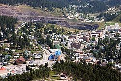
Map of Lead, SD, USA
Lead south dakota
History
The city was officially founded on July 10, 1876, after the discovery of gold. The city was named for the leads or lodes of the deposits of valuable ores. It is the site of the Homestake Mine, the largest, deepest (8,240 feet [2,510 m]) and most productive gold mine in the Western Hemisphere before closing in January 2002. By 1910, Lead had a population of 8,382, making it the second largest town in South Dakota.
Lead was founded as a company town by the Homestake Mining Company, which ran the nearby Homestake Mine. Phoebe Hearst, wife of George Hearst, one of the principals, was instrumental in making Lead more livable. She established the Hearst Free Public Library in town, and in 1900 the Hearst Free Kindergarten. Phoebe Hearst and Thomas Grier, the Homestake Mine superintendent, worked together to create the Homestake Opera House and Recreation Center for the benefit of miner workers and their families. Phoebe Hearst donated regularly to Lead's churches, and provided college scholarships to the children of mine and mill workers.
In the early 1930s, due to fear of cave-ins of the miles of tunnels under Lead's Homestake Mine, many of the town’s buildings located in the bottom of a canyon were moved further uphill to safer locations.
Lead and the Homestake Mine have been selected as the site of the Deep Underground Science and Engineering Laboratory, a proposed NSF facility for low-background experiments on neutrinos, dark matter, and other nuclear physics topics, as well as biology and mine engineering studies.
In 1974, most of Lead was added to the National Register of Historic Places under the name of the "Lead Historic District". Over 400 buildings and 580 acres (230 ha) were included in the historic district, which has boundaries roughly equivalent to the city limits.
Geography
Lead is located at 44°21′3″N 103°45′57″W (44.350967, -103.765784).
According to the United States Census Bureau, the city has a total area of 2.06 square miles (5.34 km2), all of it land.
Lead has been assigned the ZIP code 57754 and the FIPS place code 36220.
Lead's proximity to Deadwood, South Dakota, often leads to the two cities being collectively named "Lead-Deadwood".
Two prominent man-made features of Lead's geography are the giant open cut, which was used for surface gold mining by the Homestake Mine, and the resulting ridge nearby built with the non-producing material from the cut.
2010 census
As of the census of 2010, there were 3,124 people, 1,420 households, and 828 families residing in the city. The population density was 1,516.5 inhabitants per square mile (585.5/km2). There were 1,694 housing units at an average density of 822.3 per square mile (317.5/km2). The racial makeup of the city was 94.6% White, 0.3% African American, 2.0% Native American, 0.4% Asian, 0.4% from other races, and 2.3% from two or more races. Hispanic or Latino of any race were 2.9% of the population.
There were 1,420 households of which 27.6% had children under the age of 18 living with them, 40.6% were married couples living together, 13.0% had a female householder with no husband present, 4.7% had a male householder with no wife present, and 41.7% were non-families. 35.1% of all households were made up of individuals and 10.8% had someone living alone who was 65 years of age or older. The average household size was 2.19 and the average family size was 2.82.
The median age in the city was 40.5 years. 23.1% of residents were under the age of 18; 7.4% were between the ages of 18 and 24; 25.3% were from 25 to 44; 31.5% were from 45 to 64; and 12.7% were 65 years of age or older. The gender makeup of the city was 50.3% male and 49.7% female.
2000 census
As of the census of 2000, there were 3,027 people, 1,279 households, and 832 families residing in the city. The population density was 1,521.5 people per square mile (587.3/km²). There were 1,617 housing units at an average density of 812.8 per square mile (313.7/km²). The racial makeup of the city was 95.74% White, 0.23% African American, 2.25% Native American, 0.20% Asian, 0.59% from other races, and 0.99% from two or more races. Hispanic or Latino of any race were 2.71% of the population. 36.5% were of German, 8.1% English, 7.8% Irish, 7.1% Norwegian and 6.7% American ancestry according to Census 2000.
There were 1,279 households out of which 33.2% had children under the age of 18 living with them, 47.8% were married couples living together, 12.4% had a female householder with no husband present, and 34.9% were non-families. 29.2% of all households were made up of individuals and 11.8% had someone living alone who was 65 years of age or older. The average household size was 2.35 and the average family size was 2.89.
In the city, the population was spread out with 26.1% under the age of 18, 8.5% from 18 to 24, 30.2% from 25 to 44, 22.2% from 45 to 64, and 13.0% who were 65 years of age or older. The median age was 37 years. For every 100 females there were 100.9 males. For every 100 females age 18 and over, there were 96.8 males.
As of 2000 the median income for a household in the city was $29,485, and the median income for a family was $35,855. Males had a median income of $25,958 versus $18,841 for females. The per capita income for the city was $15,726. About 10.7% of families and 12.9% of the population were below the poverty line, including 15.7% of those under age 18 and 12.9% of those age 65 or over.
Recreation
In the summer, there are numerous trails for hiking, mountain biking, and horse back riding. The George S. Mickelson Trail, which runs from Edgemont to Deadwood, runs through the city. Several man made lakes, including Sheridan Lake provide fishing and swimming. Spearfish Canyon to the north has many places to rock climb.
During the winter there are two ski areas just a few miles outside of Lead. Terry Peak and Deer Mountain are both full service ski areas.