
 | ||
Similar LeConte Bay, Anan Creek Wildlife Vi, Stikine Icecap, Anan Wildlife Observat, Thomas Bay | ||
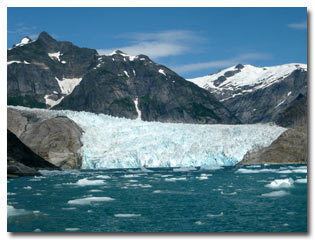
LeConte Glacier is a 21-mile (34 km) and 1-mile (1.6 km) glacier in the U.S. state of Alaska. It flows southwest to the head of LeConte Bay. It was named in 1887 by U.S. Navy Lieutenant-Commander Charles M. Thomas in honor of a California biologist Joseph LeConte. According to John Muir's book about indigenous peoples of the area, the Tlingits called it “Huti [sic]” which he claimed derived from a mythical bird that produced sounds of thunder when it flapped its wings.
Map of LeConte Glacier, Alaska 99833, USA
Since its discovery, the glacier has retreated nearly 2.5 miles (4.0 km), although it is considered to be in a stable position today [1]. The glacier is known for its "shooter" icebergs which calve off underneath the water (LeConte Bay is 810 feet (250 m) deep) and shoot out of the water due to their buoyancy.
Being south of the 57th parallel north, LeConte Glacier is the southernmost tidewater glacier of the Northern Hemisphere.
The glacier is a popular tourist destination, with operators from nearby Petersburg and Wrangell running excursions to its calving face. Students from Petersburg High School visiting also regularly to monitor its historical retreat.
Also of the same namesake and part of the Alaska Marine Highway is the ferry M/V LeConte.