
Number of households 1,765 | State Oregon Area 174 ha | |
 | ||
Restaurants Nicholas Beatty, Choptsix, Pizza Hut, Domino's Pizza, Chopsticks | ||
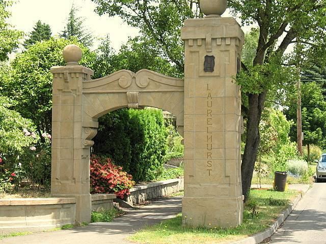
Laurelhurst portland oregon
Laurelhurst is a neighborhood of vintage homes and undulating streets surrounding a park of the same name, straddling the NE and SE sections of Portland. Stone markers flank the entrances to the area. The center of the neighborhood, Coe Circle, contains a gilded statue of Joan of Arc, which is a World War I war memorial.
Contents
Map of Laurelhurst, Portland, OR, USA
History
In 1909, the Ladd Estate Company sold its 462-acre (1.87 km2) Hazelfern Farm to the Laurelhurst Company for approximately $2 million. The name Laurelhurst was borrowed from a residential development in Seattle that Laurelhurst Company general manager Paul Murphy had recently completed. The name combined a reference to the laurel shrubbery near the Seattle development with the Old English hurst, denoting a wooded hill. The Laurelhurst Company platted a residential development of 144 acres (0.58 km2) with the help of co-investor and landscape architect John Charles Olmsted. As the first houses were being built, the city purchased 31 acres (130,000 m2) for $92,000 to construct Laurelhurst Park. Advertised as a "High Class Residence Park," the Laurelhurst Company placed numerous restrictions on the neighborhood. Similar to the Ladd's Addition development, the sale of alcohol was prohibited. Additionally, there were to be no apartments, hotels, flats, stables or commercial buildings, and no homes were to be sold to Chinese, Japanese, or African Americans.