
Country United States County Pawnee FIPS code 20-38700 Elevation 611 m Zip code 67550 Local time Sunday 5:16 PM | Time zone Central (CST) (UTC-6) GNIS feature ID 0475852 Area 6.19 km² Population 4,046 (2013) Area code 620 | |
 | ||
Weather 7°C, Wind S at 35 km/h, 62% Humidity | ||
Catch a ghost tours of kansas presents historic fort larned kansas
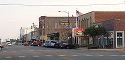
Larned is a city in and the county seat of Pawnee County, Kansas, United States. As of the 2010 census, the city population was 4,054.
Contents
- Catch a ghost tours of kansas presents historic fort larned kansas
- Map of Larned KS 67550 USA
- Ozthunder usa 2013 tornadoes larned kansas 18th may 2013
- History
- Geography
- Climate
- 2010 census
- 2000 census
- Media
- Economy
- Area attractions
- Notable people
- References
Map of Larned, KS 67550, USA
Ozthunder usa 2013 tornadoes larned kansas 18th may 2013
History
Larned was laid out in 1873. The first post office was established at Larned in 1872.
The city drew its name from nearby Fort Larned, which operated from 1859 to 1878, and named for Colonel Benjamin F. Larned, U.S. Army Paymaster from July 1854 to his death September 6, 1862.
Geography
Larned is located at 38°10′56″N 99°6′6″W (38.182109, -99.101696). According to the United States Census Bureau, the city has a total area of 2.39 square miles (6.19 km2), all land.
Climate
The climate in this area is characterized by hot, humid summers and generally mild to cool winters. According to the Köppen Climate Classification system, Larned has a humid subtropical climate, abbreviated "Cfa" on climate maps.
2010 census
As of the census of 2010, there were 4,054 people, 1,824 households, and 1,027 families residing in the city. The population density was 1,696.2 inhabitants per square mile (654.9/km2). There were 2,130 housing units at an average density of 891.2 per square mile (344.1/km2). The racial makeup of the city was 92.2% White, 2.7% African American, 0.4% Native American, 0.6% Asian, 0.1% Pacific Islander, 1.4% from other races, and 2.6% from two or more races. Hispanic or Latino of any race were 7.0% of the population.
There were 1,824 households of which 27.0% had children under the age of 18 living with them, 42.1% were married couples living together, 10.5% had a female householder with no husband present, 3.7% had a male householder with no wife present, and 43.7% were non-families. 39.5% of all households were made up of individuals and 18.6% had someone living alone who was 65 years of age or older. The average household size was 2.18 and the average family size was 2.89.
The median age in the city was 42.7 years. 23.9% of residents were under the age of 18; 6.8% were between the ages of 18 and 24; 21.9% were from 25 to 44; 27.9% were from 45 to 64; and 19.7% were 65 years of age or older. The gender makeup of the city was 48.0% male and 52.0% female.
2000 census
As of the census of 2000, there were 4,236 people, 1,826 households, and 1,113 families residing in the city. The population density was 1,823.4 people per square mile (705.0/km²). There were 2,079 housing units at an average density of 894.9 per square mile (346.0/km²). The racial makeup of the city was 90.91% White, 3.75% African American, 0.97% Native American, 0.76% Asian, 1.77% from other races, and 1.84% from two or more races. Hispanic or Latino of any race were 5.38% of the population.
There were 1,826 households out of which 27.3% had children under the age of 18 living with them, 48.6% were married couples living together, 9.0% had a female householder with no husband present, and 39.0% were non-families. 36.5% of all households were made up of individuals and 17.8% had someone living alone who was 65 years of age or older. The average household size was 2.20 and the average family size was 2.87.
In the city, the population was spread out with 23.5% under the age of 18, 6.4% from 18 to 24, 23.3% from 25 to 44, 24.6% from 45 to 64, and 22.1% who were 65 years of age or older. The median age was 43 years. For every 100 females there were 90.3 males. For every 100 females age 18 and over, there were 87.3 males.
The median income for a household in the city was $33,895, and the median income for a family was $46,776. Males had a median income of $27,138 versus $20,927 for females. The per capita income for the city was $19,936. About 5.9% of families and 7.4% of the population were below the poverty line, including 8.1% of those under age 18 and 10.8% of those age 65 or over.
Media
The local newspaper is Larned Tiller & Toiler.