
Country United States FIPS code 29-40736 Elevation 244 m Zip code 64652 Local time Sunday 3:33 PM | Time zone Central (CST) (UTC-6) GNIS feature ID 0720816 Area 73 ha Population 201 (2013) Area code 660 | |
 | ||
Weather 5°C, Wind SE at 26 km/h, 41% Humidity | ||
Laredo is a city in Grundy County, Missouri, United States. The population was 198 at the 2010 census. Laredo is pronounced "la-read-oh" which varies from the traditional pronunciation.
Contents
Map of Laredo, MO 64652, USA
History
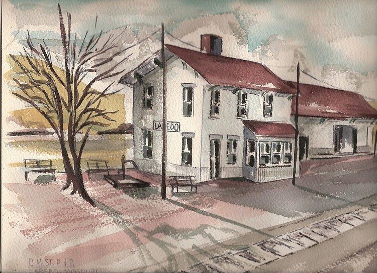
In 1887 the Chicago Milwaukee St. Paul Railroad Company purchased 240 acres of land 7.7 miles south of Galt, Missouri for a future division point, which was a midway between Kansas City and Ottumwa, Iowa. A plat of the village was filed on June 20 of that year under the name of Gorham and a sale of lots began the next day.
ALL ABOARD FOR GORHAM The opening sale of lots at Gorham, MO will take place on Tuesday, June 21, 1887 at 10:00 am. The new town is located on the Kansas City Extension of the Chicago, Milwaukee & St. Paul Railway halfway between Ottumwa, Iowa and Kansas City. It is twelve miles east of Trenton, 8.8 miles north of Chillicothe. Remember the date and be on hand.
Time tables and maps listing Gorham, MO were in the making, but before construction was completed the name of the town was changed to Laredo (Pronounced Lah-ree-doe). When application was made to the postal office department for postal service, the name of Gorham was rejected because it was so much like another town, in the state.
The first railroad service consisted of numerous stops by freight trains. While steam engine passenger trains could go about 200 miles before cleaning of the fireboxes and removing the clinkers (burnt coal cinders), freight trains were limited to 100 miles. A huge round house, with turn table, and car repair shop employed a number of town residents. This activity inspired Laredo to become a major shipping hub for the area and the railroad provided a stockyard to hold cattle until loaded for shipment to the big livestock markets in Chicago and Kansas City. On December 19, 1887, the first two passenger trains made scheduled stops at the 24-hour serviced depot at Laredo. By 1928 there were five steam engine passenger trains that were on the schedule.
Laredo became a thriving center, serving about a 1,000 people in the town and immediate area. At its peak, Laredo’s businesses included two hotels, three lumber yards, two barber shops, three grocery stores, a drug store, two hardware stores, a feed store, two restaurants, a newspaper, a jewelry store, three churches, an undertaker, a dray line, three doctors, two dentists, a blacksmith shop, a post office, and a “moving picture house”. The area was served by the Laredo Elementary School and Laredo High School.
Coal and steam engines insured the importance of Laredo as a railroad center. Then, in the early fifties, came the diesel engines. There was no longer a need for coal and water to power the engines. The station was closed in the 1970’s. It, and the roundhouse facility were razed. The loss of railroad jobs resulted in business closings and a huge population decline.
Geography
Laredo is located at 40°1′35″N 93°26′51″W (40.026341, -93.447527).
According to the United States Census Bureau, the city has a total area of 0.28 square miles (0.73 km2), all land.
2010 census
As of the census of 2010, there were 198 people, 89 households, and 59 families residing in the city. The population density was 707.1 inhabitants per square mile (273.0/km2). There were 128 housing units at an average density of 457.1 per square mile (176.5/km2). The racial makeup of the city was 99.5% White and 0.5% from two or more races.
There were 89 households of which 24.7% had children under the age of 18 living with them, 53.9% were married couples living together, 9.0% had a female householder with no husband present, 3.4% had a male householder with no wife present, and 33.7% were non-families. 28.1% of all households were made up of individuals and 9% had someone living alone who was 65 years of age or older. The average household size was 2.22 and the average family size was 2.68.
The median age in the city was 47.5 years. 16.2% of residents were under the age of 18; 10.2% were between the ages of 18 and 24; 17.7% were from 25 to 44; 32.9% were from 45 to 64; and 23.2% were 65 years of age or older. The gender makeup of the city was 49.0% male and 51.0% female.
2000 census
As of the census of 2000, there were 250 people, 113 households, and 69 families residing in the city. The population density was 913.8 people per square mile (357.5/km²). There were 138 housing units at an average density of 504.4 per square mile (197.3/km²). The racial makeup of the city was 97.20% White, and 2.80% from two or more races. Hispanic or Latino of any race were 0.80% of the population.
There were 113 households out of which 23.0% had children under the age of 18 living with them, 49.6% were married couples living together, 8.0% had a female householder with no husband present, and 38.9% were non-families. 37.2% of all households were made up of individuals and 23.9% had someone living alone who was 65 years of age or older. The average household size was 2.21 and the average family size was 2.88.
In the city the population was spread out with 25.6% under the age of 18, 5.6% from 18 to 24, 24.4% from 25 to 44, 24.4% from 45 to 64, and 20.0% who were 65 years of age or older. The median age was 41 years. For every 100 females there were 98.4 males. For every 100 females age 18 and over, there were 91.8 males.
The median income for a household in the city was $20,536, and the median income for a family was $29,688. Males had a median income of $23,828 versus $16,250 for females. The per capita income for the city was $12,451. About 13.4% of families and 19.6% of the population were below the poverty line, including 42.2% of those under the age of eighteen and 9.5% of those sixty five or over.