
Area 4.56 sq mi (11.8 km) OS grid reference SK845115 Dialling code 01572 | Population 1,371 2011 Census Unitary authority Local time Sunday 12:46 PM | |
 | ||
Weather 11°C, Wind W at 10 km/h, 88% Humidity | ||
Langham is a village and civil parish in Rutland in the East Midlands of England. The village is about 2 miles (3 km) north-west of Oakham, on the A606 main road linking Oakham and Melton Mowbray.
Map of Langham, Oakham, UK
It has two pubs, the Wheatsheaf and the Noel Arms, and a Church of England primary school. Langham Lodge is a Grade II listed house on the edge of the village.
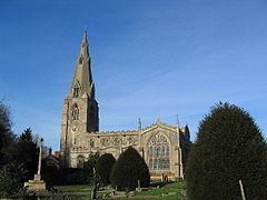
The Church of England parish church of Saints Peter and Paul dates in part from the late 13th century and is a Grade I listed building. There is also a Baptist Chapel, built in 1854.
Notable inhabitants include Simon Langham, a 14th-century monk who became Archbishop of Canterbury.
Ruddles Brewery was based in Langham from its foundation in 1858 until it was closed in 1997. The water from the local well was said to give the beer a unique character and quality, which enhanced the brewery's reputation. The site of the brewery has now been demolished and replaced by a housing development.