
State/Province DE-RP Elevation 272 m | Mountain type BasaltConical hill | |
 | ||
Similar Rockeskyller Kopf, Teufelsley, Bausenberg, Veitskopf, Raßberg | ||
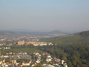
The Landskrone in the borough of Bad Neuenahr-Ahrweiler in the German state of Rhineland-Palatinate is a hill, 271.7 m above sea level (NHN), in the Middle Rhine area. It used to be called the Gimmiger Berg and Gymmicher Kupp, but is now named after the ruins of the imperial castle of Landskron which are found on its heights. On the western hillside of the Landskrone is the Chapel of Our Lady of Perpetual Succour (Maria-Hilf-Kapelle) or St. Mary's Chapel (Marienkapelle).
Contents
Map of Landskrone, 53474 Bad Neuenahr-Ahrweiler, Germany
Lage
The Landskrone is part of the northern foothills of the lower Ahr Valley. It lies east of Bad Neuenahr between Gimmigen in the north-northwest and Heppingen in the west, Heimersheim in the south and Lohrsdorf in the east, all belonging to the borough of Bad Neuenahr-Ahrweiler. To the south the River Ahr flows past from east to west, which is joined by the Leimersdorfer Bach (Heppinger Bach) to the southwest and to the Lohrsdorfer Bach to the east-southeast.