
Country United States FIPS code 55-42250 Elevation 335 m Population 3,809 (2013) Area code 608 | Time zone Central (CST) (UTC-6) GNIS feature ID 1567823 Area 7.87 km² Local time Saturday 11:59 PM | |
 | ||
Weather -7°C, Wind N at 6 km/h, 34% Humidity University University of Wisconsin–Extension | ||
Lancaster is a city in and the county seat of Grant County, Wisconsin, United States. The population was 3,868 at the 2010 census.
Contents
- Map of Lancaster WI 53813 USA
- History
- Geography
- 2010 census
- 2000 census
- Transportation
- Education
- Architecture
- High school athletics
- References
Map of Lancaster, WI 53813, USA
History
Major G.M. Price, a land speculator, laid out the town in 1837. He was persuaded to name it Lancaster by a relative who migrated from Lancaster, Pennsylvania. At Pleasant Ridge, one of the first African-American communities in Wisconsin was founded by the Shepard family in 1849 and settled in the 1850s. Lancaster was the home of the first governor of Wisconsin, Nelson Dewey.
Geography
Lancaster is located at 42°50′55″N 90°42′38″W (42.848505, -90.710430). Lancaster is located in the unglaciated "Driftless Area" of southwest Wisconsin whose topography is strikingly different from that of the rest of the state.
According to the United States Census Bureau, the city has a total area of 3.04 square miles (7.87 km2), all of it land.
2010 census
As of the census of 2010, there were 3,868 people, 1,659 households, and 1,037 families residing in the city. The population density was 1,272.4 inhabitants per square mile (491.3/km2). There were 1,805 housing units at an average density of 593.8 per square mile (229.3/km2). The racial makeup of the city was 98.3% White, 0.5% African American, 0.2% Native American, 0.5% Asian, 0.3% from other races, and 0.3% from two or more races. Hispanic or Latino of any race were 0.8% of the population.
There were 1,659 households of which 28.3% had children under the age of 18 living with them, 49.1% were married couples living together, 9.3% had a female householder with no husband present, 4.0% had a male householder with no wife present, and 37.5% were non-families. 32.4% of all households were made up of individuals and 16.6% had someone living alone who was 65 years of age or older. The average household size was 2.27 and the average family size was 2.87.
The median age in the city was 41.2 years. 23.6% of residents were under the age of 18; 7.4% were between the ages of 18 and 24; 23.1% were from 25 to 44; 26.1% were from 45 to 64; and 19.8% were 65 years of age or older. The gender makeup of the city was 47.4% male and 52.6% female.
2000 census
As of the census of 2000, there were 4,070 people, 1,706 households, and 1,079 families residing in the city. The population density was 1,441.1 people per square mile (557.2/km2). There were 1,799 housing units at an average density of 637.0 per square mile (246.3/km2). The racial makeup of the city was 99.24% White, 0.07% African American, 0.29% Asian, 0.10% from other races, and 0.29% from two or more races. Hispanic or Latino of any race were 0.42% of the population.
There were 1,706 households out of which 28.3% had children under the age of 18 living with them, 52.8% were married couples living together, 8.0% had a female householder with no husband present, and 36.7% were non-families. 31.8% of all households were made up of individuals and 18.1% had someone living alone who was 65 years of age or older. The average household size was 2.31 and the average family size was 2.93.
In the city, the population was spread out with 23.5% under the age of 18, 9.0% from 18 to 24, 25.1% from 25 to 44, 21.9% from 45 to 64, and 20.5% who were 65 years of age or older. The median age was 40 years. For every 100 females there were 89.3 males. For every 100 females age 18 and over, there were 87.0 males.
The median income for a household in the city was $32,723, and the median income for a family was $47,500. Males had a median income of $30,683 versus $22,331 for females. The per capita income for the city was $17,797. About 6.4% of families and 8.9% of the population were below the poverty line, including 8.9% of those under age 18 and 9.7% of those age 65 or over.
Transportation
Lancaster Municipal Airport (73C) serves the city and surrounding communities.
Education
Lancaster Community School District is the public school district for the community.
Architecture
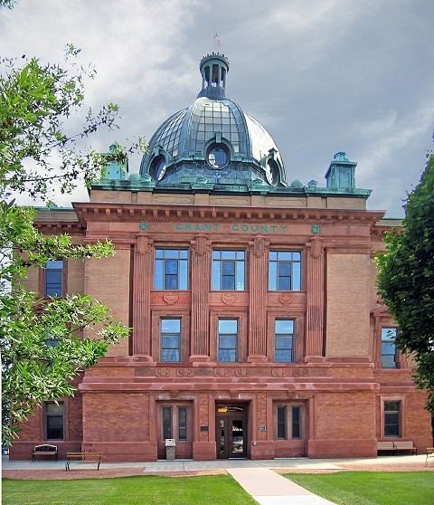
Lancaster calls itself "The City of the Dome" after the octagonal glass and copper-clad dome of its courthouse, which was designed by Armand Koch and built in 1905. In the spandrels of the courthouse dome are four allegorical murals painted by Franz Edward Rohrbeck.
The Municipal Building (1922) is an example of Prairie School early modern architecture, which, like the courthouse, has been placed on the National Register of Historic Places.
The post office contains a Depression-era mural, painted under the Works Progress Administration program in the 1930s.
The stone and wood Patrick Kinney house (1951) in Lancaster was designed by Frank Lloyd Wright, one of 45 Wright structures in Wisconsin.
High school athletics
Lancaster High's football team, the "Flying Arrows," has earned seven state titles since 1993, five of them since 2000. The "Flying Arrows" have also gone to state 2 times back to back during the 2012 and 2013 seasons. In 2001 the Associated Press named Coach John Hoch "state coach of the year", and the Green Bay Packers/Wisconsin Football Coaches Association named him "prep football coach of the year". In 2003, he was inducted into the UW-River Falls Athletic Hall of Fame.