
Area 445.2 km² | Basin countries United States Surface elevation 23 m | |
 | ||
Surface area 110,000 acres (45,000 ha) | ||
Lake Marion is the largest lake in South Carolina, centrally located and with territory within five counties. The lake is referred to as South Carolina's inland sea. It has a 315-mile (507 km) shoreline and covers nearly 110,000 acres (450 square kilometers or 173.7 square miles) of rolling farmlands, former marshes, and river valley landscape.
Contents
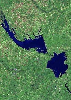
Map of Lake Marion, South Carolina, USA
The Santee River was dammed in the 1940s to supply hydroelectric power, as part of the rural electrification efforts initiated under President Franklin D. Roosevelt's New Deal during the Great Depression. It is one of the fifty largest lakes in the United States, whether natural or man-made reservoirs, but covers only about a third of the area of the fifteenth largest in size.
OriginEdit
Lake Marion was created by the construction of the Santee Dam in November 1941, part of the state-owned electric and water utility Santee Cooper's Hydroelectric and Navigation Project. The project also included the construction of the Pinopolis Dam (Cooper River Dam) to create Lake Moultrie, immediately downstream, and a diversion canal seven and a half miles long to connect the two.
The earthen Santee Dam is eight miles long and has 62 Tainter gates. Despite its size, the Santee Dam creates only 1.92 megawatts of hydropower. Hydroelectric facilities at Pinopolis Dam were designed to produce the lion's share of the original scheme: currently about 128 megawatts. In 1985, as part of a large-scale rediversion and redesign, the United States Army Corps of Engineers installed the St. Stephen Dam hydro facility to recapture lost generating capacity of another 84 megawatts.
Lake Marion is fed by many tributaries, including Wyboo Creek and the Santee River, and also by numerous springs, including Eutaw Springs. The lake is named for the American Revolutionary War General Francis Marion. His former home of Pond Bluff was one of those flooded when the lake was created.
LocationEdit
Located in five of South Carolina's counties including: Berkeley, Calhoun, Clarendon, Orangeburg, and Sumter.
Public access is provided through several public boat ramps, Santee State Park, and the Santee National Wildlife Refuge. Interstate 95 crosses the man-made lake near the Town of Santee.
WildlifeEdit
Lake Marion is known for its big fish and abundant wildlife. The state fishing record for Largemouth Bass (16.2 Ibs) was set at this lake. Other fish that abound are striped bass, white perch, white bass, crappie, channel catfish, Arkansas blue catfish, Shellcrackers, bream and Chain (Jack). Other wildlife that call Lake Marion home include deer, fox, squirrel, turtle, dove, wild turkey, alligator and various species of duck, hawk, eagle, egret and osprey.
Conditions vary from shallow swamps and blackwater ponds to vast open water with a multitude of underwater structures. The area was not completely cleared when Lake Marion was created. As a result, there are thousands of stumps, standing dead tree trunks and live cypress trees.