
Population 176 (2006 census) LGA(s) North Midlands Council Surface elevation 573 m | Postcode(s) 7210 Postal code 7210 | |
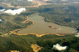 | ||
Lake Leake is the name of both a man-made water storage reservoir and a small township (Australian Postcode 7210) in the eastern midlands of Tasmania. The lake can hold 22.076 gigalitres (779,600,000 cu ft) of water. The lake was named after Charles Henry Leake a member of the Tasmanian Legislative Council. At the 2006 census, Lake Leake had a population of 176.
Contents
Map of Lake Leake TAS 7210, Australia
Features and location
The lake is used for recreational fishing, for brook trout, brown trout and rainbow trout.
The village is built on land owned by the Northern Midlands Council. Inhabitants must purchase a license to have a building there are restricted in the number of days per year they can live there. The main purpose is to accommodate recreational anglers.
Water flowing out from the lake has an electrical conductivity of 56 μS/cm.
Rawlinna is a locality located between the south side of the lake and Lake Yaleena, another water impoundment. Lake Yaleena is a privately built dammed lake, specifically for fishing. It is a business that includes accommodation in cabins.
History
The traditional custodians of the area were the peenrymairmemener clan of the North Midlands Nation. The area was originally a wetland, or series of lagoons, and was called by the peenrymairmemener Koannerwe (koan.ner.we). The area was described by contemporary colonial British as a 'resort of the natives' - an aboriginal meeting place, and contemporaries describe finding several aboriginal huts in the area. The area contains remains of aboriginal artifacts and a quarry where the peenrymairmemener crafted stone tools.
The area was renamed by colonials 'Kearney's Bogs' and then Lake Leake after the dam was constructed. The reservoir was constructed after a long debate. A 5-metre (16 ft) high dam was finished in 1884. The initial capacity was 19.9 cubic metres (700 cu ft) and an area of 6 square kilometres (2.3 sq mi). In 1971 the spillway highest point was raised by 18 centimetres (7.1 in) to increase storage capacity. Water is released for irrigation and also stored to maintain a fishing facility. Lake Leake is usually at least half full.