
Primary inflows Max. length 7.6 km (4.7 mi) Surface elevation 0 cm Mean depth 1 m Inflow source Takiritawai River | Basin countries New Zealand Max. width 1 km (0.62 mi) Area 6.276 km² Length 7.6 km Cities Little River | |
 | ||
Location Canterbury, South Island Primary outflows seepage, artificial opening Similar Akaroa Harbour, Sign of the Kiwi, Mount Herbert / Te Ahu P, Tumbledown Bay, Sign of the Takahe | ||
Lake Forsyth (known to Māori as Te Roto o Wairewa) is a lake in the Canterbury region of New Zealand.
Map of Lake Forsyth, Little River 7591, New Zealand
It is fed by the Takiritawai River, a short arm of the Okuti River, and exits via a gravel bank into the sea in the vicinity of the small community of Birdling's Flat.
State Highway 75 leading to Akaroa and part of the Little River Rail Trail follow the north-western shore of the lake.
Wairewa was an important for providing tuna [eel]s as food for the Ngai Tahu tribe (indigenous Maori people of South Island). It is the only Ngai Tahu customary lake. Wairewa Runanga one of the 18 Ngai Tahu Runanga are the guardians or kaitiaki of the lake. However deforestation of the surrounding hills has led to erosion and silting up of the lake.
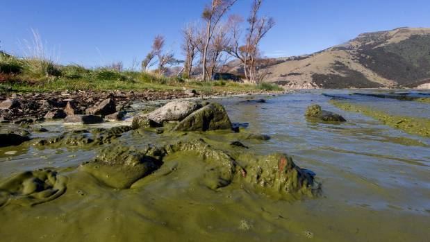
The lake is hypertrophic, leading to eutrophication with corresponding poor water quality. This decline in water quality has been known since the early 1900s. So far, attempts of opening up the lake to the ocean to rectify the problem have had limited success. In 2016, after a spell of dry weather, the water quality deteriorated and recurring algal blooms made the water toxic. Animals, including pets and sheep, died after drinking the water.