
Opening date 1936 Opened 1936 Surface area 40.4 km² | Status Operational Height 12 m Catchment area 24,475 km² Impound Souris River | |
 | ||
Similar Alameda Dam, Roosevelt Park Zoo, Super Slide, Dakota Zoo, Chahinkapa Zoo | ||
Lake Darling Dam is an earthen embankment dam on the Souris River located 20 mi (32 km) northwest of Minot, in Ward County, North Dakota. The dam began impounding water in April 1936 and was completed July of that year. It was created for the purposes of water storage and conservation. It is part of the Upper Souris National Wildlife Refuge and is owned by the United States Fish and Wildlife Service. The dam and lake are named after Jay N. "Ding" Darling, the first director of the Bureau of Biological Survey. Although the dam is located in Ward County, Lake Darling is almost entirely located in Renville County, to its north.
Map of Lake Darling Dam, Mayland, ND 58718, USA
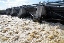
The Fish and Wildlife Service owns and operates the dam during normal conditions. During flood conditions operational control is turned over to the U.S. Army Corps of Engineers according to a 1989 memorandum of understanding. During the 2011 Souris River flood, the dam's reservoir reached maximum levels and releases of 7,500 cu ft/s (210 m3/s) in early June, contributing to flooding downstream. By June 26, releases had reached 24,000 cu ft/s (680 m3/s) and were incrementally reduced thereafter.