
Basin countries United States Area 61.71 km² Cities Farmerville | Surface area 15,250 acres (62 km) Surface elevation 24 m | |
 | ||
Location Union Parish, near Farmerville, Louisiana | ||
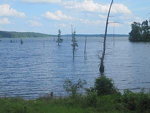
Lake D’Arbonne is a reservoir located near and around the town of Farmerville in Union Parish in north Louisiana. Isolated in a rural area, it is a popular man-made fishing area that has a combined estimated area of 15,250 acres (62 km2). The lake was first conceived in 1957 and was formed in 1963. Lake D’Arbonne State Park, a state maintained camping and recreation area, lies on the lake.
Map of Lake D'Arbonne, Louisiana, USA
State Senator B. R. Patton, State Representative T. T. Fields, landowner Alvin Green (born 1924) of Bernice, and Fred Preaus, a Farmerville automobile and timber businessman who served as state highway director in the administration of Governor Robert F. Kennon, worked to make the lake a reality.
The Louisiana State Highway 33 bridge atop Lake D'Arbonne in Farmerville is named for James Peyton Smith, the state representative from Union and Morehouse parishes from 1964 to 1972.