
Primary inflows Surface area 47 km (18 sq mi) Area 47 km² | Basin countries New Zealand Max. depth 200 m (660 ft) | |
 | ||
Inflow source Harper River, Wilberforce River | ||
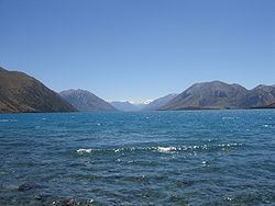
Lake Coleridge is located in inland Canterbury, in New Zealand's South Island. Located 35 kilometres to the northwest of Methven, it has a surface area of 47 km². The lake is situated in an over-deepened valley formed by a glacier over 20,000 years ago in the Pleistocene era. It currently has no natural outflows.
Map of Lake Coleridge, 7572, New Zealand
The lake is located to the north of the Rakaia River, and is the site of one of the country's earliest hydroelectric schemes, completed in 1914. The project makes use of the difference in altitude between the lake and river (the lake is 150 metres higher). Both the Harper and Wilberforce Rivers have had some of their flow diverted into the lake, with up to 100% of the Harper's flow diverted for the Lake Coleridge Power Station.
The Lake was named by the chief surveyor of the Canterbury Association, Joseph Thomas, on a sketch map prepared in early 1849. It commemorates Edward Coleridge and William Coleridge, who were first cousins and both nephews of Samuel Taylor Coleridge, two early members of the Canterbury Association. Two further members of the Coleridge family joined the Canterbury Association in June 1851, i.e. after the lake had been named: John Taylor Coleridge (a brother of Edward), and John Coleridge, one of John Taylor's sons.