
Basin countries United States Max. depth 20 ft (6.1 m) Area 5.666 km² Outflow location Flint River Cities Albany | Primary outflows Flint River Surface area 1,400 acres (6 km) Surface elevation 67 m Shore length 57.9 km Inflow source Flint River | |
 | ||
Primary inflows | ||
Lake Chehaw, also known as Lake Worth, is a small reservoir at the confluence of the Flint River, Kinchafoonee Creek, and Muckalee Creek.
Map of Lake Chehaw, Georgia 31705, USA
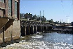
The concrete Flint River Dam was built in 1908 for hydroelectric generation and is owned by Georgia Power today. Lake Chehaw is very riverine and shallow with average depths of 17 feet. In winter, the lake is drawn down nearly 10 feet in anticipation of flooding spring rains.
In the Flood of 1994, the lake overflowed its banks and the dam itself was underwater at one point.
References
Lake Chehaw Wikipedia(Text) CC BY-SA