
Coordinates GNS Volcanic arc/belt Southern Volcanic Zone Elevation 2,160 m | Mountain type Volcanic field Last eruption 2,000 years ago | |
 | ||
Similar Caichinque, Cochiquito Volcanic Group, Yanteles, Cerro del Azufre, Huanquihue Group | ||
Laguna del Maule is a volcanic field in the Andes mountain range of Chile, close to, and partly overlapping, the Chile-Argentina frontier. The bulk of the volcanic field is in the Talca province of Chile's Maule Region. It is a segment of the Southern Volcanic Zone, part of the Andean Volcanic Belt. Many of the volcanic centres in the Laguna del Maule volcanic field formed during postglacial times, after glaciers had retreated from the area. This activity has generated cones, lava domes, lava coulees and lava flows which surround Laguna del Maule lake. The field gets its name from the lake which is also the source of the Maule river. Some of the volcanic centres were active during and before the last glaciation; at least three caldera formation events are associated with the system.
Contents
- Geography and structure
- Geology
- Local
- Composition of erupted lavas and pyroclasts
- Climate and vegetation
- Eruptive history
- Present day threat
- References
About 130 volcanic vents belong to the field and the earliest eruptions occurred 1.5 million years ago. Postglacial volcanic activity has included eruptions with simultaneous explosive and effusive components, and volcanic rocks in the field vary from basalt over andesite and dacite to rhyolite. The field was a source of obsidian with regional importance.
Between 2004 and 2007, ground inflation began in the volcanic field, indicating the intrusion of a sill beneath it. The rate of inflation is faster than those measured on other inflating volcanoes such as Uturunku in Bolivia and Yellowstone in the United States and has been accompanied by anomalies in soil gas emission and seismic activity. This pattern has created concern about the potential for impending large-scale eruptive activity.
Geography and structure
The Laguna del Maule volcanic field is centred around 36.1°S 70.5°W / -36.1; -70.5, straddling the Chilean-Argentine frontier with most of the complex on the Chilean side. The locality belongs to the Maule Region, of Talca province in the Andes mountain range, close to the confluence of the Maule and Campanario rivers in the Maule's valley. The city of Talca lies about 150 kilometres (93 mi) west. The Argentine section of the field is in the Mendoza and Neuquén provinces. Highway 115 passes through the northern part of the volcanic field, and the Paso Pehuenche mountain pass is a few kilometres northeast of the lake.
The subduction of the Nazca plate beneath the South America plate has formed a volcanic arc about 4,000 kilometres (2,500 mi) long. It is subdivided into several segments distinguished by varying angles of subduction of the Nazca plate. The part of the volcanic belt named the Southern Volcanic Zone alone contains at least 60 volcanoes with historical activity and three major caldera systems. Major volcanoes of the Southern Volcanic Zone include from north to south: Maipo, Cerro Azul, Calabozos, Tatara-San Pedro, Laguna del Maule, Antuco, Villarrica, Puyehue-Cordon Caulle, Osorno, and Chaiten. Laguna del Maule is located within a segment known as the Transitional Southern Volcanic Zone, 330 kilometres (210 mi) west of the Peru-Chile trench. Volcanoes in this segment are typically located on basement blocks that have been uplifted between extensional basins.
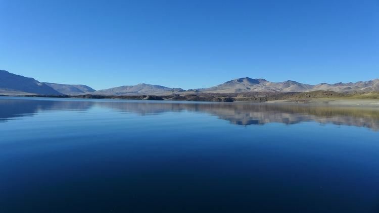
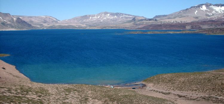
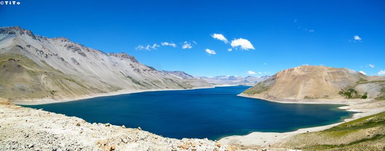
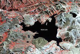
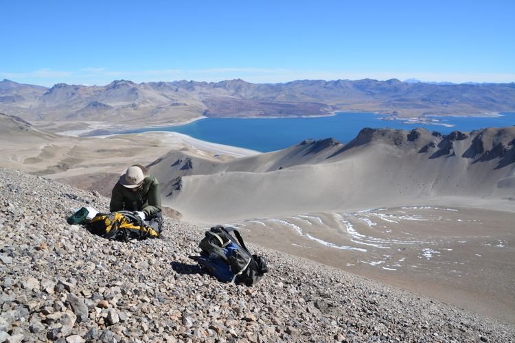
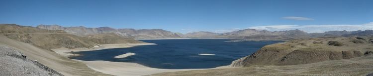
The Laguna del Maule lake lies on the crest of the Andes, within a depression with a diameter of 20 kilometres (12 mi). The lake has a depth of 50 metres (160 ft), a surface area of 54 square kilometres (21 sq mi), and the surface is at an altitude of 2,160 metres (7,090 ft). The name of the volcanic field comes from the lake, and the Maule river originates in the lake. Terraces around the lake indicate that water levels have fluctuated in the past. An eruption dated 23,300 ± 400 years ago dammed the lake 200 metres (660 ft) higher than its present level. When the dam broke, a lake outburst flood occurred leaving traces in the down-valley gorge.
The lake is surrounded by a number of Quaternary volcanic systems of various ages, including about fourteen shield volcanoes and stratovolcanoes that have been degraded by glaciation. The Laguna del Maule volcanic field covers a surface area of 500 square kilometres (190 sq mi) and contains cones, lava domes, lava flows, and shield volcanoes. There are 130 volcanic vents at Laguna del Maule. The lake is surrounded by 36 silicic coulees and lava domes. Over 100 square kilometres (39 sq mi) of the field is covered by these rocks, and ash and pumice produced by the eruptions has been found in Argentina. Presently some summits around Laguna del Maule reach altitudes of 3,900 metres (12,800 ft). The volcanic field lies at an average height of 2,400 metres (7,900 ft).
Among the various structures in the volcanic field, Domo del Maule lava dome is of rhyolitic composition and generated a northward flowing lava flow that dammed the Laguna del Maule. This lava flow is joined by other lava flows from the Crater Negro, a small cone in the southwestern sector of the volcanic field; the lavas of this cone however are andesitic and basaltic. Loma de Los Espejos is a large 4 kilometres (2.5 mi) long lava flow of acidic rocks in the northern sector of the volcanic field, close to the outlet of Laguna del Maule. This flow contains obsidian and vitrophyre and crystals within the flow reflect the sunlight. The well-preserved Colada de las Nieblas lava flow is in the extreme southwestern sector of the volcanic field. This lava flow is 6 kilometres (3.7 mi) long and 300 metres (980 ft) thick.
This area of the Andes was subject to glaciation in the past, which has left traces especially in adjacent valleys. These valleys are U-shaped or have the form of a trench, shapes associated with glacial action. The older volcanics of Laguna del Maule have been disproportionately eroded by glacial action. Slopes around Laguna del Maule are covered by colluvium including talus slopes.
The Laguna del Maule lake is not the only lake in the field. The other lakes are Laguna Cari Launa on the Chilean side in the northeastern sector of the field, and Laguna Fea in the south and Laguna Negra lake both on the Argentine side. The Laguna Sin Salida (so named because it lacks a river running out of it) is in the northeastern sector of the volcanic field and it formed within a glacial cirque.
Laguna del Maule is geothermally active, featuring bubbling pools, fumaroles and hot springs. Temperatures in these systems range between 93–120 °C (199–248 °F). The field has been evaluated as a potential source of geothermal energy. It and the neighbouring Tatara-San Pedro volcano form the so-called Mariposa geothermal system discovered in 2009, whose temperature has been estimated on the basis of gas chemistry to be 200–290 °C (392–554 °F). One estimate puts the potential productivity of Laguna del Maule as an energy source at 50–200 megawatts (67,000–268,000 hp).
Geology
Subduction of the eastern part of Nazca plate beneath the western margin of the South America Plate occurs at a rate of about 74 ± 2 millimetres per year (2.913 ± 0.079 in/year), a process which is responsible for events such as the 1960 Valdivia earthquake and the 2010 Chile earthquake. This subduction process is responsible for the growth of the Chilean Andes and the volcanic and geothermal manifestations therein.
Probably due to increased convergence rates of the Nazca and South America plates for the past 28 million years, a phase of strong volcanic activity commenced in the Andes 25 million years ago. It is likely that this phase persisted without interruption until today.
In the area of Laguna del Maule, the subducting Nazca plate reaches a depth of 130 kilometres (81 mi) and is 37 million years old there. During the Late Miocene, the convergence rate was higher than today and the Malargüe fold belt formed east of the main chain in response. The Moho is found at depths of 40–50 kilometres (25–31 mi) beneath the volcanic field.
Local
The 15.3 to 7 mya old Campanario Formation forms much of the basement in the Laguna del Maule area. This geological formation contains andesitic-dacitic ignimbrites and tuffs with later dacitic dykes that were emplaced 3.6–2.0 mya. This formation is affected by various faults that extend in north-south direction. An older unit, of Jurassic-Cretaceous age, crops out northwest of the volcanic field. Other formations include an Oligocene-Miocene lacustrine formation named Cura-Mallín, and another intermediary formation named Trapa-Trapa. Trapa-Trapa is of volcanic origin and between 19 and 10 million years old. Remnants of Quaternary ignimbrites and Pliocene, early Quaternary volcanic centres, are also found around the field.
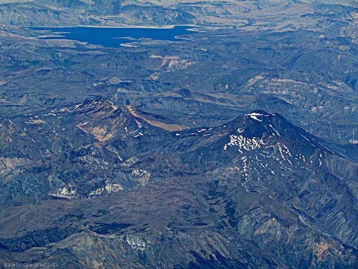
Northeast of Laguna del Maule is the 3,943 metres (12,936 ft) high Cerro Campanario, a mafic stratovolcano which was active 150,000–160,000 years ago. Nevado de Longavi volcano is located west of Laguna del Maule. The local volcanoes are in a segment of the crust where the Wadati-Benioff zone is 90 kilometres (56 mi) deep. Also west of Laguna del Maule lies the Tatara-San Pedro and Rio Colorado caldera; they may be part of a volcano alignment with Laguna del Maule. More distant are the Calabozos caldera and a late Pleistocene system with domes and flows south of Cerro San Francisquito, which are both silicic volcanic systems. The activity of Tatara-San Pedro and Laguna del Maule with the presence of rhyolite may be influenced by the subduction of the Mocha Fracture Zone, which projects in the direction of these volcanic centres.
Composition of erupted lavas and pyroclasts
Laguna del Maule has erupted basaltic andesite and andesite, with medium K content. Dacite and rhyolite are also found. Several silicic rocks are known from the Quaternary. After deglaciation, the composition of Laguna del Maule volcanic rocks has grown more silicic, with andesite eruptions being limited to the edges of the volcanic field since 19,000 years ago. Generally, the postglacial phase of activity has generated about 6.4 cubic kilometres (1.5 cu mi) of rhyolite and 1.0 cubic kilometre (0.24 cu mi) of rhyodacite. A minimum long term magma supply rate of 0.0005 cubic kilometres per year (3.8×10⁻⁶ cu mi/Ms) has been estimated. The Holocene rhyolites are glassy and contain few crystals.
Several stratigraphic units have been distinguished at the volcanic field, including the Valley unit exposed in the Maule valley and the Lake unit found around the lake. The Valley unit's rocks are basaltic andesite. Plagioclase and, in lesser measure, clinopyroxene and olivine form its phenocrysts. The mostly postglacial Lake unit includes glassy rhyolite, which is poor in crystals. Phenocrysts in the postglacial rocks are biotite, plagioclase and quartz. Microlites in the Lake unit rocks include biotite, plagioclase and spinel. Variable vesicular texture has been noted on rocks erupted during different eruptions. Temperatures of the postglacial magmas have been estimated at 820–950 °C (1,510–1,740 °F).
The postglacial rocks have very similar element compositions. In the Loma de Los Espejos rocks a SiO
2 content of 75.6–76.7% per weight has been noted. High Al and low Ti are present in the basaltic andesite and basalt, a typical pattern for basic rocks in zones where plates converge. The rocks overall belong to the calc-alkaline series, although some Fe-rich rocks have been attributed to the tholeiitic series. Sr isotope ratios have been compared to the ones of Tronador volcano; additional compositional similarity is found to other volcanoes close to Laguna del Maule such as Cerro Azul and Calabozos. Laguna del Maule stands out for the frequency of rhyolitic rocks, compared to volcanoes farther south in the chain. There are compositional trends in the region of the volcanic arc between 33°-42°, with more northerly volcanoes being more andesitic in composition while to the south basalts are more frequent.
All the postglacial activity appears to originate from a shallow silicic magma chamber beneath the caldera, which acts as a trap for mafic magma, preventing it from rising to the surface. The early post-glacial rhyodacites contain mafic inclusions. From Sr isotope ratios it has been inferred that the magma is of deep origin, and the rare earth element composition shows no evidence of crustal contamination. Nd and Sr isotope ratios indicate all rocks are derived from the same parent source, with the rhyolites forming by fractional crystallization of the basic magma, similar to the postulated origins of rocks from the Central Volcanic Zone. Partial melting may also be the source of the rhyolites. Overall the environment where the rocks formed appears to be an oxidized 760–850 °C (1,400–1,560 °F) system that formed over 100,000 – 200,000 years, and was influenced by the injection of basaltic magma. The rhyolitic melts may originate in a crystal rich mush beneath the volcanic field.
It has been suggested that Laguna del Maule is an important source of obsidian for the region, on both sides of the Andes. Finds have been made from the Pacific to Mendoza 400 kilometres (250 mi) away from the coast, as well as at archaeological sites of Neuquén province. Obsidian forms sharp edges and was used by ancient societies for the production of projectiles as well as cutting instruments. In South America, obsidian was traded over large distances. Obsidian has been found in the Arroyo El Pehuenche (35°58′52″S 70°23′35″W), Laguna Negra (36°12′25″S 70°24′28″W) and Laguna del Maule (35°59′57″S 70°25′35″W) localities. These sites yield obsidians with varying properties, from large blocks at Laguna del Maule to smaller pebbles probably carried by water at Arroyo El Pehuenche.
Climate and vegetation
Laguna del Maule lies at the interface between a semi-arid, temperate climate and a colder montane climate. Average yearly temperatures from 2007 to 2013 ranged 8.1–10.3 °C (46.6–50.5 °F). Cold front related precipitation falls during autumn and winter, although occasional summer storms also contribute to rainfall. Laguna del Maule is subject to the rain shadow effect of mountains farther west, leading to a lack of glaciation at the numerous summits exceeding 3,000 metres (9,800 ft) in altitude around the lake. Most of the lake water comes from snowmelt; for much of the year the landscape around the lake is covered with snow.
The area of Laguna del Maule was glaciated during the last ice age, with a maximum occurring between 25,600±1,200 and 23,300±600 years ago. Probably due to changes in the position of the Westerlies, after c. 23,000 years ago the glaciers retreated above Laguna del Maule. The glaciation has left moraines and terraces in the area, with undulating hills lying close to the outlet of the Laguna del Maule. Poorly developed moraines with the appearance of insignificant hills lie downstream of Laguna del Maule, and such moraines form small hills around the lake rising about 10–20 metres (33–66 ft) above the lake level.
The landscape around Laguna del Maule is mostly desertic without trees. Vegetation around Laguna del Maule is principally formed by cushion plants and sub-shrubs, with higher altitudes displaying more scattered vegetation. The rocks around Laguna del Maule host a plant named Leucheria graui which has not been found elsewhere.
Eruptive history
Laguna del Maule has been active since 1.5 mya ago, with a total rock output of over 350 cubic kilometres (84 cu mi). At least three caldera forming events occurred during the system's lifespan, at 1.5 mya (dacitic Laguna Sin Puerto ignimbrite, the ignimbrite is exposed northwest of Laguna del Maule lake), 950,000 (rhyodacitic Bobadilla caldera, the ignimbrite from this caldera-forming event borders Laguna del Maule lake in the north) and 336,000 years ago generating welded ignimbrites. This last ignimbrite is known as Cordon Constanza ignimbrite. The Bobadilla caldera is centred beneath the northern shore of the Laguna del Maule, and has dimensions of 12 by 8 kilometres (7.5 mi × 5.0 mi). In total, volcanic output at Laguna del Maule has been estimated to be 200,000 cubic metres per year (220,000 cu ft/Ms), comparable to other volcanic arc systems, with eruptions occurring about every 1000 years.
The rhyodacitic lava domes and flows which surround the lake were erupted from 25,000 years ago forwards, after the onset of deglaciation, until the last such eruption approximately 2,000 years ago. Preceding activity includes the rhyolitic Cajon Atravesado 712,000 years ago north of the lake, the rhyodacitic Cerro Negro 468,000–447,000 years ago in the northeastern parts of the field, the rhyodacitic Arroyo Cabeceras de Troncoso 203,000 years ago northwest of the lake, and the unit known as "Valley unit" with basic rocks of a volume of 5 cubic kilometres (1.2 cu mi). This unit was erupted 240,000±50,000 to 200,000±70,000 years ago and in the Maule valley outcrops it appears as lava flows thinning to the top. A unit of basalt pyroclastic cones and lava flows in the northwest of the field has been dated 100,000±20,000 to 170,000±20,000 years ago from two samples. Other volcanic activity took place 154,000 years ago, forming the basaltic Bobadilla Chica vent and lava north of the lake, and 152,000 years ago forming the andesitic Volcan de la Calle vent and lava straddling the Chile-Argentina border in the eastern sector. Later eruptive activity formed the rhyodacite Domo del Maule (36°1′45″S 70°34′35″W) 114,000 years ago northwest of Laguna del Maule, a neighbouring rhyodacite west of Laguna del Maule dam, basaltic El Candado (36°0′45″S 70°33′40″W) 63,000–62,000 years ago near the outlet of Laguna del Maule, a rhyolite east of the outlet 38,000 ± 29,000 years ago, and andesites also west of the dam 27,000–26,000 years ago named Arroyo Los Mellicos.
Silicic volcanic units erupted after 25,000 include young andesites on the western coast of Laguna del Maule 24,000 years ago, rhyodacitic Arroyo de la Calle 21,000 years ago southeast of Laguna del Maule and rhyolitic Loma de Los Espejos (36°0′0″S 70°32′0″W) 19,000 years ago in the northern part of the field. These units have a volume of 1.7 cubic kilometres (0.41 cu mi). After that point activity shifted and the volume output increased, with the subsequent units having a volume of 4.8 cubic kilometres (1.2 cu mi). These two phases of volcanic activity occurred within 9,000 years of each other and the magmas involved may have been sourced from different magma reservoirs. This phase includes the rhyolitic Cerro Barrancas (36°10′0″S 70°27′0″W) 7,000 years ago in the southeastern part of the field, and an associated 15 kilometres (9.3 mi) long pyroclastic flow, rhyolitic Cari Launa (36°3′0″S 70°25′0″W) 3,500 years ago in the northeastern part of the field, as well as rhyolitic Colada Divisoria and Colada Las Nieblas (36°7′0″S 70°32′0″W) 2,000 years ago in the eastern and southwestern parts of the field, respectively. Other proposed dates are 23,000 years ago for the Espejos rhyolite, 14,500 years ago for the Cari Launa rhyolite, 6,400 and 3,900 years ago for the Barrancas complex and 2,200 years ago for the Colada Divisoria. Undated postglacial units are andesitic Crater Negro (36°4′10″S 70°32′0″W) scoria cone and lava flow just west of Laguna del Maule, andesitic Playa Oriental on the southeastern shore of Laguna del Maule, rhyolitic Arroyo de Sepulveda at Laguna del Maule and rhyodacitic Colada Dendriforme in the western part of the field. This rhyolitic flare up has no precedents in the history of the volcanic field. Three mafic volcanic vents named Arroyo Cabeceras de Troncoso, Crater 2657 and Hoyo Colorado are also considered postglacial. The former two are andesitic, while the latter is a pyroclastic cone.
Explosive activity including ash and pumice has accompanied a number of the postglacial eruptions, the largest is associated with Los Espejos and has been dated 23,000 years ago. The deposit of this Plinian eruption reaches 4 metres (13 ft) of thickness at a distance of 40 kilometres (25 mi). White ash and pumice form layered deposits east of the Loma de Los Espejos. Other such explosive events have been dated at 7,000, 4,000 and 3,200 years ago by radiocarbon dating. It has been estimated that the ash and pumice deposits have a volume comparable with that of the lava flows.
A tephra layer in the Argentine Caverna de las Brujas dated 7,780 ± 600 years ago has been tentatively linked to Laguna del Maule, and another with a thickness of 80 centimetres (31 in) 65 kilometres (40 mi) away from Laguna del Maule is dated 765 ± 200 years ago and appears to coincide with a time with no archaeological findings in the high cordillera. Other tephras which possibly were erupted at Laguna del Maule have been found in Argentinian archaeological sites, one 7,195 ± 200 years ago at El Manzano and another 2,580 ± 250 to 3,060 ± 300 years old at Cañada de Cachi. The El Manzano tephra reaches a thickness of 3 metres (9.8 ft) about 60 kilometres (37 mi) away from Laguna del Maule and would have had a severe impact on Holocene human communities south of Mendoza.
Present day threat
Laguna del Maule is a volcanic system that undergoes strong deformation, starting between 2004 and 2007 the ground in the volcanic field has been uplifting. This deformation attracted the attention of the global scientific community after it was detected by radar interferometry. Between January 2006 and January 2007 uplift of 18 centimetres per year (7.1 in/year) were measured, with uplift during 2012 amounting to about 28 centimetres per year (11 in/year). Between 2007 and 2011 the uplift almost reached 1 metre (3 ft 3 in). A change in the deformation pattern occurred in 2013 at the time of an earthquake swarm in January 2013. As estimated in 2016 the uplift rate was 25 centimetres per year (9.8 in/year). The uplift is one of the strongest in all volcanoes which are not in eruption; the strongest uplift worldwide was recorded during 1982–84 at Campi Flegrei in Italy with an end change of 1.8 metres (5 ft 11 in). Other actively deforming dormant volcanoes in the world are Lazufre also in Chile, Santorini in Greece during 2011–12, and Yellowstone in the United States, the last one at a rate of 1/7th that of Laguna del Maule. Another South American volcano, Uturunku in Bolivia has been inflating at a pace 1/10th that of Laguna del Maule's. There is evidence that earlier deformations occurred at Laguna del Maule, with the lake shores having risen by about 67 metres (220 ft) during the Holocene.
The current uplift has its centre beneath the western segment of the ring of post-glacial lava domes, more specifically beneath the southwestern sector of the lake. The source of the deformation has been traced to an inflation of a sill, with dimensions of 9.0 by 5.3 kilometres (5.6 mi × 3.3 mi) 5.2 kilometres (3.2 mi) deep beneath the volcanic field. This sill has been inflating at an average pace of 31,000,000 ± 1,000,000 cubic metres per year (34,700,000 ± 1,100,000 cu ft/Ms) between 2007 and 2010. The rate of volume change has changed between 2011 and 2012, with an increase in the volume change rate. As of July 2016, 2,000,000 cubic metres per year (2,200,000 cu ft/Ms) of magma are estimated to enter the magma chamber. This volume change is approximately 10 to 100 times as large as the field's long term magma supply rate. Gravimetric analysis has indicated that between April 2013 and January 2014, approximately 0.044 cubic kilometres (0.011 cu mi) of magma intruded beneath the field. The presence of a sill is also supported by magnetotelluric measurements indicating conductivity anomalies at depths of 4–5 kilometres (2.5–3.1 mi) beneath the western side of the volcanic field, indicating the presence of rhyolitic melt.
Strong seismic activity has accompanied the deformation at Laguna del Maule, with seismic swarms recorded above the depth of the deforming sill south of the ring of lava domes, with a particular focus around Colada Las Nieblas. A further magnitude 5.5 earthquake occurred south of the volcanic field on June 2012. A major volcano-tectonic earthquake swarm occurred in January 2013, possibly due to faults and underground liquids being pressurized by the intrusion of magma. As of July 2016 the earthquake rate was 4 earthquakes per month. The 2010 Maule earthquake, 230 kilometres (140 mi) west of Laguna del Maule, did not affect the volcanic field, with the rate of uplift remaining unchanged, while other measurements indicate a change in the uplift rates at that point.
Several reasons have been proposed for the inflation, including the movement of magma underground, the injection of new magma, or the action of volcanic gases and volatiles which are released by the magma. Another proposal is that the inflation may be situated in a hydrothermal system. CO
2 anomalies have also been found around Laguna del Maule, possibly triggered by the stress of the inflation activating old faults. These anomalies are concentrated on the northern lakeshore. Such CO
2 may indicate that the inflation is of mafic composition, as rhyolite only poorly dissolves CO
2.
This uplift has been cause of concern in light of the history of explosive activity of the volcanic field, with 50 eruptions in the last 20,000 years. A major eruption would have a serious impact on Argentina and Chile, including the formation of lava domes, lava flows, pyroclastic flows near the lake, and ash fall at larger distances. In March 2013, the Southern Andean Volcano Observatory declared an "yellow alert" for the volcano in light of the deformation and earthquake activity.