
Max. depth 181 m (594 ft) Area 127 ha | Primary outflows Brenno di Luzzone Surface area 1.27 km (0.49 sq mi) Surface elevation 1,606 m Catchment area 36.74 km² | |
 | ||
Primary inflows Similar Luzzone Dam, Alps, Greina, Lukmanier Pass, Rheinwaldhorn | ||
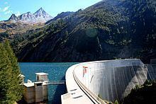
Lago di Luzzone is a reservoir in Ticino, Switzerland. The reservoir has a volume of 108 million m³ and a surface area of 1.27 km2 (0.49 sq mi). It is located in the upper Blenio valley, on the territory of the municipalities of Ghirone and Aquila.
Map of Lago di Luzzone, Blenio, Switzerland
The reservoir lies at a height of 1,606 metres above sea level and is surrounded by peaks over 3,000 metres. The highest is Piz Terri (3,149 m), on the north-east side of the lake, seconded by the Plattenberg (3,041 m), on the east side. The Torrone di Nav (2,832 m) overlooks the lake from the south side while Pizzo Pianca (2,377 m) overlooks the lake from the north side.
The arch dam Luzzone was completed in 1963. In the years 1997–1998, its height was increased by 17 m.
One wall of the dam currently features the world's highest artificial climbing wall. A German manufacturer of climbing holds installed a line of over 650 artificial holds and bolts. The course covers a vertical distance of 165 meters, going from the base of the dam to the top. The climb must be done as a sport climb, in multiple pitches. Furthermore, the lowest holds were placed several meters above the ground to deter casual visitors from climbing on them.