
Opened 24 May 1930 | Daily traffic 38,000 (2013) Total length 262 m Province Québec | |
 | ||
Width 15.5 metres (51 ft) (northbound) Similar Médéric Martin Bridge, Louis Bisson Bridge, Le Gardeur Bridge, Papineau‑Leblanc Bridge, Charles de Gaulle Bridge | ||
'Lachapelle Bridge', in French Pont Lachapelle, (1930 and 1975) Also known as Cartierville Bridge.
Map of Pont Lachapelle, Qu%C3%A9bec, Canada
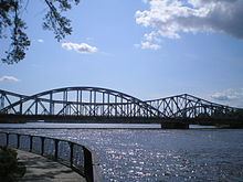
This bridge spans the Rivière des Prairies between the Montreal borough of Ahuntsic-Cartierville and the Laval (Île Jésus) neighbourhood of Chomedey.
Actually there are two bridges, side by side and parallel:
The older (1930) three lane span, on the down stream side, carries the traffic north into Laval.
The newer (1975) three lane span, on the up stream side, carries the traffic south into Montreal.
Except for the length and the distance between the piers, the two spans are not identical.
A wooden bridge was originally built there in 1836, replaced by a steel one, built in 1882.
References
Lachapelle Bridge Wikipedia(Text) CC BY-SA