
Surface elevation 1,358 m | Catchment area 3.5 km² | |
 | ||
Similar Alps, Aravis Range, Chapelle des Confins, Col des Aravis, Tardevant | ||
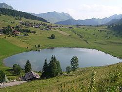
Lac des Confins is located just below the station of La Clusaz in the Haute-Savoie department in the Rhône-Alpes region in south-eastern France. The lake is situated at the foot of the Aravis Range. Nearby is the Pointe Percée.
Map of Lac des Confins, 74220 La Clusaz, France
Every year, at the end of the skiing season, there is a light-hearted descent. The skiers run down the hills towards the lake as fast as they can, the idea being to see who can jump the furthest into the lake. All participants are encouraged.
References
Lac des Confins Wikipedia(Text) CC BY-SA