
Country Canada RCM Les Laurentides Constituted January 1, 1881 Area 385.5 km² Local time Friday 3:09 PM | Region Laurentides Settled 1881 Time zone EST (UTC−5) Population 1,892 (2011) Province Québec | |
 | ||
Weather -10°C, Wind NW at 6 km/h, 47% Humidity | ||
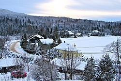
Lac-Supérieur is a municipality in the Laurentides region of Quebec, Canada, part of the Les Laurentides Regional County Municipality. It is named after Lake Superior (Lac Supérieur) which is located in the Laurentian Mountains, due east of Mont Tremblant Resort. The community of Lac-Supérieur is just south of the lake, which itself is ringed with cottages. The entire northern portion of the municipality is mostly undeveloped and part of the Mont-Tremblant National Park.
Contents
Map of Lac-Sup%C3%A9rieur, QC, Canada
History
The municipality was formed in 1881 and initially named Wolfe, in tribute to British General James Wolfe. Its first settlers were Canadians repatriated from California and the western United States.
In 1944, the municipality was renamed to Saint-Faustin, the name of the parish founded in 1878 in what is now part of Saint-Faustin–Lac-Carré. In 1957, it was renamed again to its present name, a designation previously assigned to the post office which opened in 1913.
Demographics
Population trend:
Private dwellings occupied by usual residents: 872 (total dwellings: 1654)
Mother tongue: