
UBIGEO 0408 | Elevation 2,388 m (7,835 ft) Area 4,746 km² Region Arequipa Region | |
 | ||
Website www.municotahuasi.gob.pe | ||
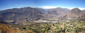
La Unión is a province of the Arequipa Region in Peru. Its seat is Cotahuasi.
Contents
Map of La Uni%C3%B3n Province, Peru
Geography
The Wansu mountain range traverses the province. One of the highest peaks of the province is Sulimana at 6,093 metres (19,990 ft). Other mountains are listed below:
Political division
The province is divided into eleven districts which are
Ethnic groups
The people in the province are mainly indigenous citizens of Quechua descent. Quechua is the language which the majority of the population (59.18%) learnt to speak in childhood, 40.06% of the residents started speaking using the Spanish language (2007 Peru Census).
References
La Unión Province, Peru Wikipedia(Text) CC BY-SA