
Country Colombia Subregion Southwestern Area 55 km² | Department Antioquia Department Elevation 600 m (2,000 ft) Local time Friday 3:10 AM | |
 | ||
Time zone Colombia Standard Time (UTC-5) Weather 23°C, Wind W at 3 km/h, 85% Humidity | ||
Near launch la pintada colombia
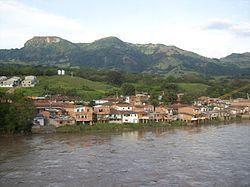
La Pintada ([la pinˈtaða]); is a town and municipality in the southwest region of the Antioquia department. It is located seventy nine miles away from Medellín and is at an altitude of six hundred meters over sea level. It borders the Fredonia and Santa Bárbara municipalities to the north. The Cauca River goes through the municipality.
Contents
Map of La Pintada, Antioquia, Colombia
Places of interest
References
La Pintada, Colombia Wikipedia(Text) CC BY-SA