
Traversed by D113 | Elevation 1,564 m | |
 | ||
Location | ||
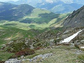
La Hourquette d'Ancizan (elevation 1,564 m (5,131 ft)) is a mountain pass in the French Pyrenees in the department of Hautes-Pyrénées, between the communities of Ancizan (east) and Campan (west).
Contents
- Map of La Hourquette dAncizan 65440 Ancizan France
- ToponymyEdit
- Details of climbEdit
- Appearances in Tour de FranceEdit
- References
Map of La Hourquette d'Ancizan, 65440 Ancizan, France
ToponymyEdit
The word "Hourquette" is derived from the Gascon word "hurketɵ" meaning "farm". Or, according to French Wikipedia, the Gascon word comes from the Latin furca meaning a fork.
Details of climbEdit
Starting from Ancizan, the climb is 10.3 km (6.4 mi) long. Over this distance, the climb is 805 m (2,641 ft) (an average of 7.8%). After Ancizan, the road goes up sharply, with stretches of 15% in the first kilometre, but after the first 3 km (1.9 mi), the climb becomes more moderate.
Starting from Campan, the climb is 22.6 km (14.0 mi) long. Over this distance, the climb is 904 m (2,966 ft) (an average of 4.0%), with the steepest section being at 10.0%.
On both sides of the climb mountain pass cycling milestones are placed every kilometre. They indicate the height of the summit, the distance to the summit, the current height, and the average slope in the following kilometre. Such signposting for cyclists has become common in most major mountain passes in the French Pyrenees and Alps.
Appearances in Tour de FranceEdit
La Hourquette d'Ancizan was first used in the Tour de France on stage 12 of the 2011 tour, when the leader over the summit was Laurent Mangel.
The climb was also used in the 2013 tour on the 168.5 km "roller-coaster" stage 9 from Saint-Girons to Bagnères-de-Bigorre. Dan Martin from Garmin-Sharp won the stage.