
Official name La Grange Dam Opening date 1883 Height 40 m Length 85 m | Spillway type Inlet-drop Opened 1883 Catchment area 4,004 km² | |
 | ||
Owner Modesto Irrigation District Similar Tuolumne River, New Don Pedro Dam, Basso Bridge, Don Pedro Dam, Sierra Nevada | ||
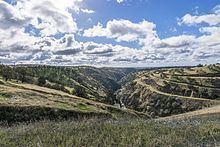
The La Grange Dam is a masonry-gravity diversion dam on the Tuolumne River near La Grange, California. The dam was completed in 1883 by the Turlock Irrigation District and Modesto Irrigation District in an effort to divert water into their canal systems for local farmers.
Map of La Grange Dam, La Grange, CA 95329, USA
The La Grange Dam is two miles (3 km) downstream of the New Don Pedro Dam and not only serves to regulate its outflows but diverts water from the Don Pedro’s much larger reservoir into two canals on either side of the river. Each year, an average of 885,000 acre feet (1.092×10⁹ m3) of water is diverted. About 575,000 acre feet (709,000,000 m3) goes through TID's canal to Turlock Lake and another 310,000 acre feet (380,000,000 m3) goes through MID's canal to Modesto Reservoir. Nearly all of this water irrigates crops in the Turlock and Modesto Irrigation Districts. Another 230,000 acre feet (280,000,000 m3) goes to San Francisco's Hetch Hetchy Water and Power. And, finally, about 780,000 acre feet (960,000,000 m3) of water is delivered to the Tuolumne River channel to maintain flows in the 52 miles (84 km) of the Lower Tuolumne River through its confluence with the San Joaquin River and then into the Sacramento-San Joaquin Delta.
The La Grange Dam also diverts water to a small 4 MW hydroelectric power station above the east bank of the Tuolumne River that is operated by the Turlock Irrigation District.