Trisha Shetty (Editor)

La Frontera, Santa Cruz de Tenerife

Updated on
Edit
Like
Comment
Share on FacebookTweet on TwitterShare on LinkedInShare on Reddit
Country
  
Island
  
Climate
  
BSh

Area
  
84.2 km²

Autonomous community
  
Postal code
  
E-38911

Elevation
  
300 m

Local time
  
Friday 3:47 AM

La Frontera, Santa Cruz de Tenerife httpsuploadwikimediaorgwikipediacommonsthu

Weather
  
27°C, Wind SW at 14 km/h, 34% Humidity

La Frontera (Spanish for "the border") is a municipality in the northwestern part of the island El Hierro, Santa Cruz de Tenerife, Canary Islands, Spain. In 2007, the southern part of the territory of La Frontera was split off to form the new municipality of El Pinar.

Contents

Map of 38911 Frontera, Santa Cruz de Tenerife, Spain
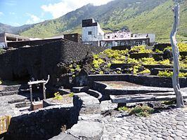
Sites of interest

  • Punta de la Orchilla - a lighthouse situated in the west of the municipality. The lighthouse was first constructed to represent the old meridian. It used to mark the meridian line or the 0 degree-line at the lighthouse which was put by the French in 1634. Many 16th and 17th century maps had the prime meridian at Punta de la Orchilla. In 1884 the International Meridian Conference agreed to use the meridian of Greenwich as the standard prime meridian. Before the meridian change, El Hierro was known as Isla del Meridiano (Meridian Island).
  • La Dehesa - here is the hermitage of the Virgen de los Reyes, patron saint of the island of El Hierro
  • References

    La Frontera, Santa Cruz de Tenerife Wikipedia


    Similar Topics