
Country Canada Constituted February 9, 2000 Postal code(s) G0L 1K0 Area 222 km² Province Québec Area code 418 | Region Bas-Saint-Laurent Time zone EST (UTC−5) Highways
A-20 (TCH) Route 132 Population 1,469 (2011) Local time Sunday 10:09 PM RCM Bas-Saint-Laurent | |
 | ||
Weather -2°C, Wind NE at 5 km/h, 69% Humidity | ||
L'Isle-Verte is a small municipality located along the south shore of the Saint Lawrence River, in the Rivière-du-Loup Regional County Municipality of the Bas-Saint-Laurent region, Quebec, Canada. The name of the village refers to Île Verte (French for "Green Island"), a nearby island that is not within its municipal boundaries. Village and island are joined by a seasonal ferry.
Contents
Map of L'Isle Verte, QC, Canada
It is known for its lamb, fed in a salted marsh, a luxury product in Quebec. Its marshes along the Saint Lawrence River are a protected bird sanctuary part of the Baie de l’Isle-Verte Ramsar wetland.
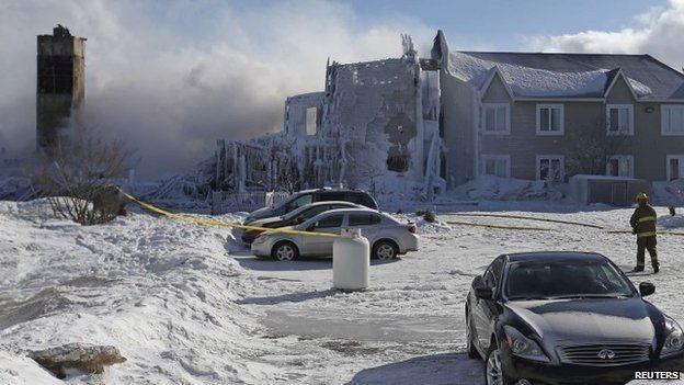
On January 23, 2014, a major fire destroyed the Résidence du Havre, a home for the elderly, killing thirty-two residents.
Demographics
Population trend:
Private dwellings occupied by usual residents: 616 (total dwellings: 681)
Languages: