
Local time Monday 3:10 AM | Area 13.67 km² | |
 | ||
Region Bourgogne-Franche-Comté Weather 10°C, Wind SW at 10 km/h, 85% Humidity | ||
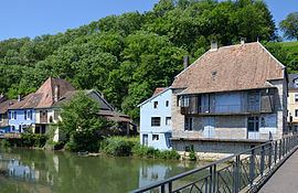
L'Isle-sur-le-Doubs is a commune in the Doubs department in the Bourgogne-Franche-Comté region in eastern France.
Contents
Map of 25250 L'Isle-sur-le-Doubs, France
Geography
The communes is situated 65 km (40 mi) northeast of Besançon and 25 km (16 mi) southwest of Montbéliard. The town lies at the foot of a cliff, so expansion took place on the other side of the Doubs River.
History
The town of l'Isle-sur-le-Doubs was formed from the merging of the villages of Fusnans, Carnans, and Uxelles. It belonged originally to the abbey of Les Trois Rois, and was then ceded to the Count of Neufchâtel, who built his castle there in 1230, only the foundations of which remain.
Population
The inhabitants of the commune are called l'Islois.
Tourism
The commune has a three-star camping ground and attracts many tourists who go fishing in the Doubs. Hiking trails are also numerous in the surrounding countryside.