
Area 12.4 km² Population 249 (1999) | Region Occitanie Canton Nant Time zone CET (UTC+1) Local time Monday 2:57 AM | |
 | ||
Weather 7°C, Wind NW at 23 km/h, 96% Humidity | ||
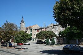
L'Hospitalet-du-Larzac is a commune in the Aveyron department in southern France, part of the southern Massif central, incorporating part of the Larzac plateau.
Map of 12230 L'Hospitalet-du-Larzac, France
The economy is agricultural, notably dairy produce (Roquefort cheese), but also beef and mutton production, and rural tourism.
L'Hospitalet-du-Larzac is the site of discovery of one of the longest and most important inscriptions in the Gaulish language, a lead curse tablet (found in 1983).
The commune is named for a historical hospital founded by vicount Millau Gilbert (or Guibert) in 1108. It was owned by Cassan Abbey from 1174 to 1789.The parish church was at Saint-Étienne-du-Larzac, now ruined, in what is now part of Sainte-Eulalie-de-Cernon commune. The hospital was fortified in the early 15th century, after which the parish center was transferred there. The current parish church dates to 1764, presumably built on top of an older structure.
In 1807, the parish was enlarged, incorporating d’Egalières, du Sambuc, Trinquier and du Rouquet. The modern commune was formed in 1834, with the dissolution of the predecessor commune of La Cavalerie.