
Prominence 533 m | Elevation 2,794 m Parent range Glarus Alps | |
 | ||
Similar Hausstock, Tödi, Glärnisch, Ortstock, Gufelstock | ||
Chli k rpf
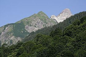
The Kärpf (or Chärpf) is a mountain in the Glarus Alps, at an elevation of 2,794 m (9,167 ft). The Kärpf is the highest point of the massif lying north of Richetli Pass (2,261 m or 7,418 ft). This range separates the two main valleys of Glarus: the main Linth valley with the village of Linthal on the west and the Sernftal with the village of Elm on the east.
Contents
- Chli k rpf
- Map of KC3A4rpf 8767 Glarus SC3BCd Switzerland
- Timelapsaufnahme der milchstrasse ber dem k rpf
- References
Map of K%C3%A4rpf, 8767 Glarus S%C3%BCd, Switzerland
On the north side of the Kärpf is located a small valley, which is occupied by a lake, the Garichtisee.
Administratively, the mountain lies in the municipality of Glarus Süd, in the canton of Glarus.
Timelapsaufnahme der milchstrasse ber dem k rpf
References
Kärpf Wikipedia(Text) CC BY-SA