Area 8.15 km² Local time Sunday 10:19 AM | Region Kantō Phone number 042-576-2111 Population 75,867 (Feb 2016) | |
 | ||
Weather 13°C, Wind N at 14 km/h, 54% Humidity Colleges and Universities | ||
Kunitachi (国立市, Kunitachi-shi) is a city located in the western portion of Tokyo Metropolis, in the central Kantō region of Japan. As of 1 February 2016, the city had an estimated population of 75,867 and a population density of 9310 persons per km². Its total area was 8.15 square kilometres (3.15 sq mi).
Contents
- Map of Kunitachi Tokyo Japan
- Geography
- Surrounding municipalities
- History
- Education
- Railway
- Highway
- Local attractions
- References
Map of Kunitachi, Tokyo, Japan
Geography
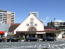
Kunitachi is located in the Musashino Terrace of central Tokyo Metropolis. Kunitachi is known for its broad main avenue, Daigaku Dori (University Avenue). This cherry-tree-lined boulevard stretches from Kunitachi Station on the Chūō Main Line toward the banks of the Tama River.
Surrounding municipalities
History
Kunitachi lies along the historical Kōshū Kaidō, a route that connected Edo with Kofu in the province of Kai (present-day Yamanashi Prefecture). The modern villages of Yaho, Aoyagi and Yabo were created within Tama District of Kanagawa Prefecture during the establishment of the municipalities system on April 1, 1889. The district was transferred from Kanagawa to Tokyo in 1893. The three villages were merged to form Kunitachi town in 1951. Kunitachi was elevated to city status on January 1, 1967.
