
Basin size 956 km (369 sq mi) Basin area 956 km² Source Subotička Peščara Country Serbia | Length 109 km Source elevation 131 m Mouth Danube–Tisa–Danube Canal | |
 | ||
Main source Subotička Peščara, Vojvodina, Serbia
131 m (430 ft) River mouth Canal Danube-Tisa-Danube at Turija, Vojvodina, Serbia | ||
The Krivaja (Serbian Cyrillic: Криваја) is a river in northern Serbia. With the length of 109 km (68 mi) it is the longest river that flows completely within the borders of Serbian province of Vojvodina.
Contents
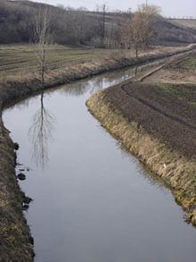
Map of Krivaja, Serbia
Upper Course
The Krivaja springs out in the Subotička Peščara, from the several streams which meet southwest of the village of Žednik. The longest stream originates from Pavlovac hillock (Cyrillic: Павловац) northeast of Bajmok, one of the most populous villages in Vojvodina. The stream passes between the village of Đurđin and Jaramazov hillock (Cyrillic: Јарамазов) before it meets the shorter, northern stream (already named the Krivaja) and continues to the south.
The river passes next to the villages of Mali Beograd and Zobnatica, a tourist resort and site of the famous stud-farm, before it reaches the town of Bačka Topola. At Zobnatica, the Krivaja is dammed, creating 5.5 km long artificial Zobnatica lake, with an area of 2,55 km², used for irrigation and tourism.
Lower Course
The river turns west after the Bačka Topola and then turns sharply again to the southeast, near the village of Bajša and all three settlements that constitute the municipality of Mali Iđoš: the small town of Mali Iđoš and the villages of Lovćenac and Feketić. At the town of Srbobran, the Krivaja turns east, carving a shallow, 15 km long valley, in which it meanders for 33 km before it empties into the Great Bačka Canal, part of the Canal Danube-Tisa-Danube. Total meandering ratio of the whole river is 65:109 (in the valley 15:33), thus the name (Krivaja; Serbian for winding river). The village of Turija stands on the Krivaja's mouth into the canal, at an altitude of 76 m.
The Krivaja drains an area of 956 km2, belongs to the Black Sea drainage basin and it is not navigable.