
Republic Crimea Time zone MSK (UTC+4) Area code(s) +380-6554 Area 95 ha | District Bakhchysarai Raion Postal code 98464 Elevation 120 m Population 1,663 (2014) | |
 | ||
Country Disputed
Russia, Ukraine Weather 3°C, Wind SE at 3 km/h, 87% Humidity | ||
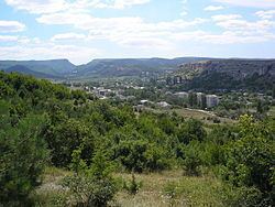
Krasny Mak (Ukrainian: Красний Мак; Russian: Красный Мак; Crimean Tatar: Büyük Qaralez) is a selo in Bakhchysarai Raion of the Autonomous Republic of Crimea, a territory recognized by a majority of countries as part of Ukraine and incorporated by Russia as the Republic of Crimea. It is located in the Crimean Mountains, southerly of Bakhchysarai. The village stretches along the Bystryanka creek, a tributary of the river Belbek. Population: 1,663 (2014 Census).
Map of Krasnyi Mak
Near the village are the medieval hillforts of Mangup and Eski-Kermen. During the Soviet period, Krasny Mak became a local center, where blocks of flats have been constructed.
References
Krasnyi Mak Wikipedia(Text) CC BY-SA