
Country Japan District Kitatsuru Area 52.78 km² Local time Saturday 3:22 AM | Region Chūbu
Tōkai Phone number 0428-87-0111 Population 720 (1 Nov 2015) Prefecture Yamanashi Prefecture | |
 | ||
Time zone Japan Standard Time (UTC+9) Address 4698 Kosuke-mura, Kitatsuru-gun, Yamanashi 409-0211 Weather -2°C, Wind W at 6 km/h, 61% Humidity Points of interest Kosuge Hot Spring, Forest Adventure Kosuge, Odaki | ||
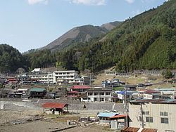
Kosuge (小菅村, Kosuge-mura) is a village located in Kitatsuru District, Yamanashi Prefecture, Japan. As of November 2015, the village had an estimated population of 720 and a population density of 13.6 persons per km². The total area was 52.65 square kilometres (20.33 sq mi).
Contents
- Map of Kosuge Kitatsuru District Yamanashi Prefecture Japan
- Geography
- Neighboring municipalities
- History
- Economy
- Highway
- References
Map of Kosuge, Kitatsuru District, Yamanashi Prefecture, Japan
Geography
Kosuge is located in the mountainous far northeastern corner of Yamanashi Prefecture. Much of the land in the village is protected watershed forest within the Chichibu Tama Kai National Park, providing water for the Tokyo Metropolis.
Neighboring municipalities
Yamanashi Prefecture
Tokyo Metropolis
History
During the Edo period, all of Kai Province was tenryō territory under direct control of the Tokugawa shogunate. During the cadastral reform of the early Meiji period in July 1, 1889, the village of Kosuge was created within Kitatsuru District, Yamanashi Prefecture. Discussions to merge with the neighboring city of Kōshū, Yamanashi in 2008 have been shelved.
Economy
The economy of Kosuge is primarily based on forestry and agriculture.