
Elevation 513 m | Postal code 378 42 Area 5.85 km² | |
 | ||
Website | ||
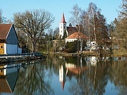
Kostelní Radouň is a village and municipality (obec) in Jindřichův Hradec District in the South Bohemian Region of the Czech Republic.
Map of 378 42 Kosteln%C3%AD Radou%C5%88, Czechia
The municipality covers an area of 5.85 square kilometres (2.26 sq mi), and has a population of 259.
Kostelní Radouň lies approximately 9 kilometres (6 mi) north of Jindřichův Hradec, 48 km (30 mi) north-east of České Budějovice, and 105 km (65 mi) south-east of Prague.
References
Kostelní Radouň Wikipedia(Text) CC BY-SA