
Distance to Malé 213.75 km (132.82 mi) | Geographic atoll Miladhummadulhu Atoll Time zone MST (UTC+05:00) | |
 | ||
Komandoo (Dhivehi: ކޮމަންޑޫ) Code c-13 is one of the inhabited islands of the Shaviyani Atoll administrative division and geographically part of the North Miladhummadulhu Atoll in the Maldives.
Map of Komandoo, Maldives
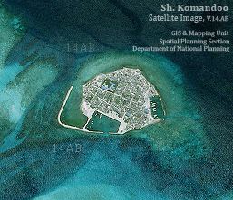
Komandoo is one of the islands of Shaviyanil Atoll. Situated 213 km North West of Male’, the island measures 315 meters in length and 250 meters in width. Komandoo is the smallest in size of about 9 hectares but the second most populated island in Shaviyani Atoll with a current population of about 1,900 people.
Shaviyani Atoll Education Centre is the biggest school in the atoll. Students can join at grade 1 at the age of 7 years and complete their A’ Levels at the end of their 12th grade at this school. Those students doing A’ Levels can complete Commerce and science stream for their studies at Shaviyani Atoll Education Centre. The biggest Teacher Training Center is in Komandoo.
Services provided by the Health Center include blood transfusion, E.C.G, laboratory investigations and family planning. Other services available in Komandoo include speed boat rental services, Wireless internet connection, and cable TV service.
Komandoo is one of the special islands in the Maldives. There are 3 community associations including PSA(Past Students Association), AKYD(Komandoo Youth Development Association)and KMG(Komandoo Fishermens Association). They have special things uncommon to other islands. Konmandoo have their own facilities including Electricity, TV.station, desalination water plant,FM radio, slipway and their own phone network.