
 | ||
The Kochersberg is a natural region of the French département of Bas-Rhin in Alsace and is a part of the hills found along the eastern side of the Vosges mountains. It gave its name to the Community of Communes of the Kochersberg.
Map of Kochersberg, 67370 Neugartheim-Ittlenheim, France
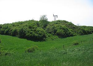
Its name comes from the Kochersberg hill; its highest peak (301 m), stands over Neugartheim-Ittlenheim.
A castle was built on its top in the 13th century but was destroyed three centuries later. Its only relief is its peripheral ditch.
Between 1794 and 1797, a semaphore tower was built in its place. It was the second relay (after Dingsheim), of the optical telegraph line from Strasbourg to Paris via Saverne and its pass and was used until 1852.
This relay has been replaced in the late 20th century by a motionless memorial which can still be seen (weather permitting), from ten kilometers away.