
Area code(s) (+48) 032 Population 12,738 (2006) | Time zone CET (UTC+1) Area 17.5 km² | |
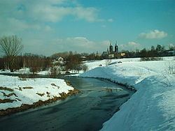 | ||
Kochłowice (German: Kochlowitz) is a district in the south-east of Ruda Śląska, Silesian Voivodeship, southern Poland. It has an area of 17.5 km2 and in 2006 it was inhabited by 12,738 people.
Contents
Map of Koch%C5%82owice, Ruda Slaska, Poland
History
Archaeological excavations in 2007 surfaced traces of a settlement on the territory of Kochłochwice existing already in the 9th century. The village was first mentioned in 1360 as Kochlowa Lanka. In the 16th and 17th century a salt mill (Salzhütte) operated here, the only such establishment in the Bytom state country. The village was affected by industrial development in the 19th century (coal mines)
After World War I in the Upper Silesia plebiscite 3364 out of 4427 voters in Kochłowice voted in favour of joining Poland, against 968 opting for staying in Germany. Afterwards it became a part of Silesian Voivodeship, Second Polish Republic. It was then annexed by Nazi Germany at the beginning of World War II. After the war it was restored to Poland.
Kochłowice was merged into Nowy Bytom in 1951, and as part of Nowy Bytom was amalgamated with Ruda to form Ruda Śląska on December 31, 1958.