
Area 8.94 km² | Region Ústí nad Labem Postal code 411 16 Elevation 239 m Local time Thursday 3:30 AM | |
 | ||
Weather 5°C, Wind W at 18 km/h, 74% Humidity | ||
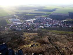
Klapý is a village and municipality (obec) in Litoměřice District in the Ústí nad Labem Region of the Czech Republic.
Map of Klap%C3%BD, Czechia
The municipality covers an area of 8.94 square kilometres (3.45 sq mi), and has a population of 534 (as at 31 December 2007).
Klapý lies approximately 14 kilometres (9 mi) south-west of Litoměřice, 26 km (16 mi) south of Ústí nad Labem, and 49 km (30 mi) north-west of Prague.
References
Klapý Wikipedia(Text) CC BY-SA