
Borough Northwest Arctic Elevation 13 ft (4 m) Zip code 99750 Local time Wednesday 4:07 PM | Incorporated June 23, 1969 Time zone Alaska (AKST) (UTC-9) Population 382 (2013) | |
 | ||
Weather -24°C, Wind W at 0 km/h, 69% Humidity Area 10.1 km² (4.921 km² Land / 5.18 km² Water) | ||
Kivalina alaska island is sinking no and it s not an island pics
Kivalina (kiv-uh-LEE-nuh; Kivalliñiq in Iñupiaq) is a city and village in Northwest Arctic Borough, Alaska, United States. The population was 377 at the 2000 census and 374 as of the 2010 census.
Contents
- Kivalina alaska island is sinking no and it s not an island pics
- Map of Kivalina AK USA
- History
- Geography
- Demographics
- Environmental issues
- Kivalina v ExxonMobil Corporation
- Orange goo
- References
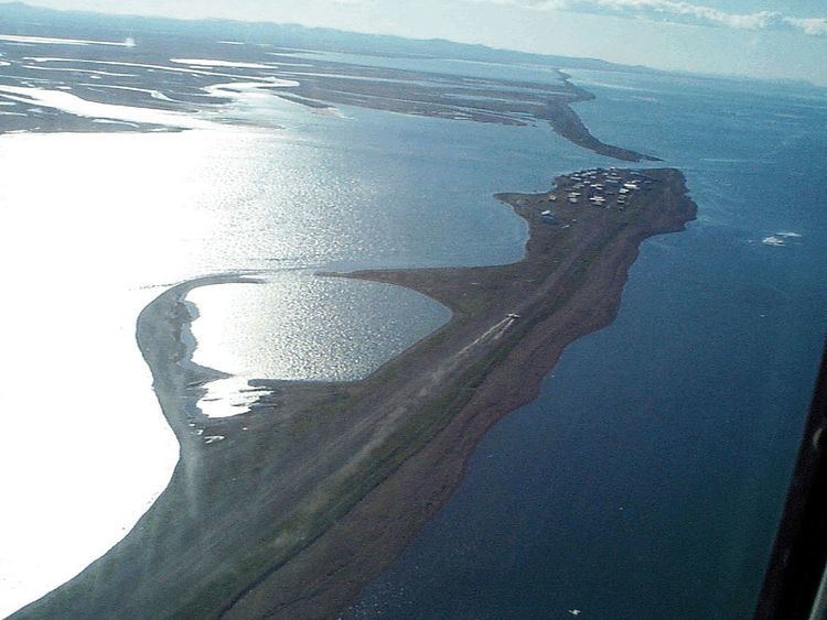
Map of Kivalina, AK, USA
The island on which the village lies is threatened by rising sea levels and coastal erosion. As of 2013, it is predicted that the island will be inundated by 2025.
History
Kivalina is an Inupiat community first reported as "Kivualinagmut" in 1847 by Lt. Lavrenty Zagoskin of the Imperial Russian Navy. It has long been a stopping place for travelers between Arctic coastal areas and Kotzebue Sound communities. Three bodies and artifacts were found in 2009 representing the Ipiutak culture, a pre-Thule, non-whaling civilization that disappeared over a millennium ago.
It is the only village in the region where people hunt the bowhead whale. The original village was located at the north end of the Kivalina Lagoon but was relocated.
In about 1900, reindeer were brought to the area and some people were trained as reindeer herders.
An airstrip was built at Kivalina in 1960. Kivalina incorporated as a second-class city in 1969. During the 1970s, a new school and an electric system were constructed in the city.
On December 5, 2014 the only general store in Kivalina burned down. In July 2015, a newer store was opened after months of rebuilding to make the store more convenient and safe.
Geography
Kivalina is on the southern tip of a 12 km (7.5 mi) long barrier island located between the Chukchi Sea and a lagoon at the mouth of the Kivalina River. It lies 130 km (81 mi) northwest of Kotzebue.
According to the United States Census Bureau, the village has a total area of 3.9 square miles (10 km2), of which, 1.9 square miles (4.9 km2) of it is land and 2.0 square miles (5.2 km2) of it (51.55%) is water.
Demographics
As of the census of 2000, there were 377 people, 78 households, and 64 families residing in the village. The population density was 202.1 people per square mile (77.8/km²). There were 80 housing units at an average density of 42.9 per square mile (16.5/km²). The racial makeup of the village was 3.45% White and 96.55% Native American.
There were 78 households out of which 61.5% had children under the age of 18 living with them, 62.8% were married couples living together, 15.4% had a female householder with no husband present, and 17.9% were non-families. 16.7% of all households were made up of individuals and 3.8% had someone living alone who was 65 years of age or older. The average household size was 4.83 and the average family size was 5.50. In the village the population was spread out with 44.0% under the age of 18, 13.3% from 18 to 24, 20.7% from 25 to 44, 15.9% from 45 to 64, and 6.1% who were 65 years of age or older. The median age was 21 years. For every 100 females there were 106.0 males. For every 100 females age 18 and over, there were 113.1 males.
The median income for a household in the village was $30,833, and the median income for a family was $30,179. Males had a median income of $31,875 versus $21,875 for females. The per capita income for the village was $8,360. About 25.4% of families and 26.4% of the population were below the poverty line, including 27.9% of those under age 18 and 30.0% of those age 65 or over.
Environmental issues
Due to severe sea wave erosion during storms, the city hopes to relocate again to a new site 12 km (7.5 mi) from the present site; studies of alternate sites are ongoing. According to the U.S. Army Corps of Engineers, the estimated cost of relocation runs between $95 and $125 million, whereas the Government Accountability Office (GAO) estimates it to be between $100 and $400 million. Kivalina's environmental issues were prominently featured in The 2015 Weather Channel documentary "Alaska: State of Emergency" hosted by Dave Malkoff. Kivalina was one of the two towns featured in the Al Jazeera English Fault Lines documentary, When the Water Took the Land. The community, who were originally nomadic, were given an ultimatum that they would have to settle in the permanent community or their children would be taken from them.
Kivalina v. ExxonMobil Corporation
The city of Kivalina and a federally recognized tribe, the Alaska Native Village of Kivalina, sued Exxon Mobil Corporation, eight other oil companies, 14 power companies and one coal company in a lawsuit filed in federal court in San Francisco on February 26, 2008, claiming that the large amounts of greenhouse gases they emit contribute to global warming that threatens the community's existence. The lawsuit estimates the cost of relocation at $400 million. The suit was dismissed by the United States district court on September 30, 2009, on the grounds that regulating greenhouse emissions was a political rather than a legal issue and one that needed to be resolved by Congress and the Administration rather than by courts.
Kivalina has also sued Canadian mining company Teck Cominco for polluting its water source.
Orange goo
On August 4, 2011, it was reported that residents of the city of Kivalina had seen a strange orange goo wash up on the shores. According to the Associated Press, "Tests have been conducted on the substance on the surface of the water in Kivalina. City Administrator Janet Mitchell told the Associated Press that the substance has also shown up in some residents' rain buckets." On August 8, 2011, Associated Press reported that the substance consisted of millions of microscopic eggs. Later, officials of the National Oceanic and Atmospheric Administration (NOAA) confirmed that the orange colored materials were some kind of crustacean eggs or embryos, but subsequent examination resulted in a declaration that the substance consisted of spores from a possibly undescribed species of rust fungus, later revealed to be Chrysomyxa ledicola.