
Population 208 (2011 census) Postal code 2539 | Postcode(s) 2539 Local time Wednesday 2:25 AM | |
 | ||
Weather 21°C, Wind NE at 10 km/h, 90% Humidity Points of interest Merry Beach, Kioloa Beach, Shelly Beach | ||
Kioloa is a small hamlet located on the South Coast of New South Wales, Australia and is within the City of Shoalhaven local government area. It is pronounced by locals as 'Ky-ola'. At the 2011 census, Kioloa had a population of 208 people.
Map of Kioloa NSW 2539, Australia
The Australian National University's Kioloa Coastal Campus is north of the town.
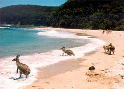
Its neighbour is Bawley Point, which is accessed via Murramerang Road, the only sealed access road in and out of Kioloa. Both of these villages rely mainly upon tourism as a source of income. Kioloa has three large caravan parks offering a range of accommodation options to suit all budgets and one general store. The area is well known throughout the region for its pristine beaches and peak surfing conditions. As an isolated coastal retreat, Kioloa is infamous among holiday-goers for its lack of mobile phone reception.
Kioloa is the southern terminus of local bus services provided on weekdays by Ulladulla Bus Lines. Route 741 runs twice daily from Kioloa to Ulladulla via Bawley Point, Termeil, Tabourie and Burrill Lake. An additional afternoon service runs on school days.