
- elevation 8,382 ft (2,555 m) Length 64 km | - elevation 4,114 ft (1,254 m) | |
 | ||
- location Quinn River Lakes, Humboldt County, Nevada, Nevada | ||
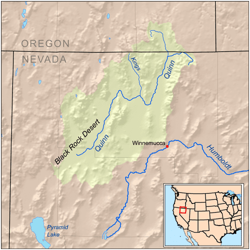
The Kings River is a tributary of the Quinn River, about 40 mi (64 km) long, in northwestern Nevada and south-central Oregon in the United States. It drains a remote arid area of the northwestern Great Basin.
Map of Kings River, Nevada, USA
The river rises in northern Humboldt County, Nevada, west of Disaster Peak in The Granites, part of the Trout Creek Mountains, near the Oregon state line. Flowing northwest, it crosses briefly into Harney County, Oregon, then turns sharply south and re-enters Nevada for the rest of its course. It flows generally south between the Bilk Creek Mountains on the right (west) and the Montana Mountains, then the Double H Mountains on the left. It joins the Quinn River from the north at Quinn River Lakes. The Quinn River flows southwest from the lake to end in a sink in the Black Rock Desert west of Winnemucca.