
Population 1,202 (2011 Census) Region East Midlands Sovereign state United Kingdom Shire county Northamptonshire District East Northamptonshire UK parliament constituency Corby | OS grid reference TL0097 Country England Post town Peterborough Local time Tuesday 10:29 AM Dialling code 01780 | |
 | ||
Weather 12°C, Wind W at 24 km/h, 84% Humidity | ||
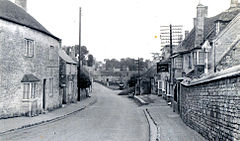
Kings Cliffe (variously spelt King's Cliffe, King's Cliff, Kings Cliff, Kingscliffe) is a village and civil parish on Willow Brook, a tributary of the River Nene, about 9 miles (14 km) northeast of Corby in East Northamptonshire. The parish adjoins the county boundary with the City of Peterborough and the village is about 12 miles (19 km) west of the city centre. The village is not far from the boundary with Lincolnshire and about 6 miles (10 km) south of Stamford.
Contents
- Map of Kings Cliffe Peterborough UK
- Population
- Parish church
- Economic and social history
- Notable residents
- References
Map of King's Cliffe, Peterborough, UK
Population
The 2001 Census recorded a parish population of 1,137 people, increasing to 1,202 at the 2011 Census.
The 1871 Census recorded a parish population of 1259. The 1891 Census recorded the parish population as having fallen to 1,082, occupying 262 "inhabited houses"
Parish church
The Church of England parish church of All Saints has a central tower that is Norman, with late 13th century upper parts and broach spire. The nave has a Decorated Gothic west window and there are north and south aisles with 14th century arcades. The font is also 14th century. Later features are the Perpendicular Gothic clerestory, roof and remodelling of the north and south arches supporting the tower. Inside the church is a monument erected in 1623 to the Thorpe family, whose descendant John Thorpe (1565–1655) was a notable Elizabethan and Jacobean architect.
Economic and social history
Hall Yard Farmhouse was built in 1603. Inside the house, Dr Law's Music Room has an 18th-century Georgian coved ceiling with decoration in the style of Robert Adam. Law's Chapel, also 18th century, is nearby.
Parts of Kings Cliffe Manor House are early 17th century.
Kings Cliffe is unusual in having three sets of almshouses. The John Thorpe Almshouses were built in 1668, the Widows' Almshouses in 1749 and the Spinsters' Almshouses in 1754. The Widows' and Spinsters' almshouses were part of a set of charities founded by Rev. Dr William Law (1686–1761) and his disciple, Mrs Elizabeth Hutcheson. A house dating from about 1700 was made a Schoolmaster's House in 1745, and next to it the Boys' School was built in 1748. From 1752 the Schoolmaster's House became Law's Library, which housed Law's religious books and lent them to people of King's Cliffe and neighbouring towns.
King's Cliffe railway station was on a branch line that ran between Seaton and Wansford. The London and North Western Railway opened it in 1879 and British Railways closed it in 1966.
RAF Kings Cliffe was opened in 1942 and returned to agricultural use in 1959. It was about 1.5 miles (2.4 km) east of the village.