
Country United States County Columbia Established 1788 Elevation 73 m Zip code 12106 Area code 518 | State New York Settled 1750 Time zone Eastern (EST) (UTC-5) Founded 1788 Population 8,498 (2010) | |
 | ||
Weather -5°C, Wind S at 6 km/h, 42% Humidity Area 83.92 km² (82.36 km² Land / 155 ha Water) | ||
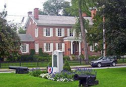
Kinderhook is a town in the northern part of Columbia County, New York, United States. The population was 8,498 at the 2010 census, the most populous municipality in Columbia County. The name of the town means "Children's Corner" in the language of the original Dutch settlers (Kinderhoek). The town of Kinderhook contains two villages, one of which is also named Kinderhook, where the eighth President of the United States, Martin Van Buren, was born; the other is the village of Valatie. In addition, the town contains the hamlet of Niverville, next to Kinderhook Lake.
Contents
History
In 1609 Henry Hudson sailed as far north as Kinderhook on his exploration of the Hudson River and named the location "Kinderhoek". Kinderhook signifies in the Dutch tongue "the children's corner", and is supposed to have been applied to this locality, in 1609, on account of the many Indian children who had assembled on one of the bluffs along the river to see his strange vessel (the Half Moon) sailing upstream. Another version says that a Swede named Scherb, living in the forks of an Indian trail in the present town of Stuyvesant, had such a numerous family of children that the name of Kinderhook was used by the Dutch traders to designate that locality. Hudson had mixed dealing with the local Mohican natives, ranging from peaceful trade to minor skirmishes. As the Dutch attempted to colonize the area, further warfare broke out with the natives.
Kinderhook was settled before 1651 and established as a town in 1788 from a previously created district (1772), but lost substantial territory to form part of the town of Chatham in 1775. Kinderhook was one of the original towns of Columbia County. More of Kinderhook was lost to form the town of Ghent in 1818 and the town of Stuyvesant in 1823.
Geography
According to the United States Census Bureau, the town has a total area of 32.4 square miles (83.9 km2), of which 31.8 square miles (82.4 km2) is land and 0.62 square miles (1.6 km2), or 1.87%, is water, including Kinderhook Lake, Kinderhook Creek, and the waterfalls of Valatie.
The north town line is the border of Rensselaer County.
Kinderhook Creek is an important stream in the town, flowing southwest toward tidal Stockport Creek, an arm of the Hudson River. U.S. Route 9 and New York State Route 9H pass through the town.
Demographics
As of the census of 2000, there were 8,296 people, 3,165 households, and 2,247 families residing in the town. The population density was 260.6 people per square mile (100.6/km²). There were 3,434 housing units at an average density of 107.9 per square mile (41.7/km²). The racial makeup of the town was 97.31% White, 0.68% Black or African American, 0.23% Native American, 0.86% Asian, 0.04% Pacific Islander, 0.33% from other races, and 0.57% from two or more races. Hispanic or Latino of any race were 1.41% of the population.
There were 3,165 households out of which 33.3% had children under the age of 18 living with them, 58.5% were married couples living together, 8.9% had a female householder with no husband present, and 29.0% were non-families. 24.0% of all households were made up of individuals and 10.1% had someone living alone who was 65 years of age or older. The average household size was 2.52 and the average family size was 3.01.
In the town, the population was spread out with 24.5% under the age of 18, 5.8% from 18 to 24, 27.2% from 25 to 44, 27.0% from 45 to 64, and 15.5% who were 65 years of age or older. The median age was 41 years. For every 100 females there were 93.5 males. For every 100 females age 18 and over, there were 89.8 males.
The median income for a household in the town was $52,604, and the median income for a family was $61,074. Males had a median income of $41,386 versus $27,880 for females. The per capita income for the town was $24,259. About 2.8% of families and 4.6% of the population were below the poverty line, including 5.3% of those under age 18 and 4.4% of those age 65 or over.
Tourism
President Martin Van Buren's retirement home, Lindenwald, is in the town of Kinderhook. The Luykas Van Alen House, a National Historic Landmark (c.1737), is thought to be author Washington Irving's inspiration for the "Van Tassel family" farm in his classic story "The Legend of Sleepy Hollow", as Irving — a friend of Van Buren — was a frequent visitor and sometime resident to the area. The Ichabod Crane Schoolhouse is in Kinderhook and now sits on the Van Alen property. The schoolhouse is a 19th-century rural schoolhouse.
The James Vanderpoel House, known as "The House of History", on Broad Street in Kinderhook village was built circa 1819 and is an important example of high-style Federal architecture that is owned and maintained by the Columbia County Historical Society. The "Old Columbia Academy" was an early Dutch school established on March 13, 1787. The school was renamed "Kinderhook Academy" on April 3, 1824.
Government
Patrick Grattan is the Town Supervisor. He was elected in November 2009. He defeated incumbent Supervisor Douglas McGivney by a 2-1 margin.