
- left Granby River - average 2,906 cu ft/s (82 m/s) Discharge 82.29 m³/s Country United States of America Cities Grand Forks | - elevation 1,500 ft (457 m) Length 282 km Basin area 10,878 km² Bridges Curlew Bridge | |
 | ||
- right West Kettle River, Rock Creek - location Franklin D. Roosevelt Lake, Washington (state) - max 35,000 cu ft/s (991 m/s) Mouths Franklin D. Roosevelt Lake, Columbia River | ||
The Kettle River is a 175-mile (282 km) tributary of the Columbia River in northeastern Washington in the United States and southeastern British Columbia in Canada. Its drainage basin is 4,200 square miles (11,000 km2) large, of which 3,177 square miles (8,230 km2) are in Canada and 1,023 square miles (2,650 km2) in the United States. The indigenous name of the river in the Okanagan language is nxʷyaʔłpítkʷ (Ne-hoi-al-pit-kwu.)
Contents
Map of Kettle River, Washington, USA
CourseEdit
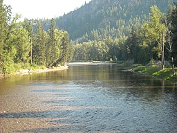
From its source at the outlet of Holmes Lake in the Monashee Mountains of British Columbia, the Kettle River flows south to Midway, British Columbia. Along the way it is joined by many tributaries, most notably the West Kettle River. Below Midway, the river loops south, crossing the Canada–US border into the United States, through Ferry County, Washington, before flowing north back into Canada, passing by Grand Forks, British Columbia where the Granby River joins. After flowing east for about 10 miles (16 km), the river turns south again, just south of Christina Lake, entering the United States again. It then flows south, forming part of the Ferry-Stevens County line, before joining the Columbia River near Kettle Falls, Washington. The Columbia River at this point is a large reservoir impounded behind Grand Coulee Dam, called Lake Roosevelt. The Kettle enters the lake at the Columbia's river mile 706. The Kettle River is undammed, making it one of the extremely few rivers with constant flow in the Pacific Northwest.
Natural historyEdit
The Kettle River once supported salmon and other anadromous fish. The construction of Grand Coulee Dam, along with Chief Joseph Dam, blocked fish migration up the Columbia and its upper tributaries, including the Kettle River. In addition, Grand Coulee Dam's reservoir, Lake Roosevelt, flooded traditional fishery sites, including Kettle Falls near the mouth of the Kettle River.