
Population 359 (2011) Post town IPSWICH Local time Sunday 2:30 PM District Babergh | Sovereign state United Kingdom Postcode district IP7 6 | |
 | ||
Weather 14°C, Wind NW at 6 km/h, 61% Humidity | ||
Kersey suffolk february 1987
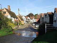
Kersey is a village and a civil parish in the Babergh district in Suffolk, in the east of England. The main street has a ford across a stream. Its principal claim to fame is that a coarse woollen cloth called Kersey cloth takes its name from it. The cloth was presumably originally made there, but later in many other places too.
Contents
Map of Kersey, UK
The parish contains the village of Kersey and the hamlets of Kersey Tye, Kersey Upland, Wicker Street Green and William's Green. Kersey's church is St Mary's, and the village also contains a primary school.
The population of the village is about 350, measured at 359 at the 2011 Census.
References
Kersey, Suffolk Wikipedia(Text) CC BY-SA