
Catchment area Vuoksi Max. length 29 km (18 mi) Surface elevation 80 m Shore length 452.6 km | Surface area 85.57 km (33.04 sq mi) Area 8,557 km² | |
 | ||
Primary inflows Primary outflows Kerma Rapids, to Enonvesi | ||
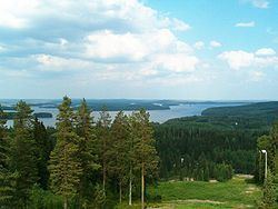
Kermajärvi (literally Finn. kerma for cream, järvi for lake) is a medium-sized lake in the Vuoksi main catchment area. It is located in the region of Southern Savonia in Heinävesi. It is the country's 53rd largest lake with an area of 85.57 square kilometres (33.04 sq mi) and consists of a wide open lake with plenty of islands in both northwest and southeast parts of it and several long, narrow bays in both ends.
Map of Kermaj%C3%A4rvi, Hein%C3%A4vesi, Finland
The lake gets its water from Varisvesi of Kallavesi by Karvio Rapids and flows through Kerma and Vihovuonne Rapids to Ruokovesi which flows through Pilppa Rapids to Haukivesi of Saimaa. Kermajärvi is the main lake of Heinävesi Route, one of the two routes which Lake Kallavesi flows through to Saimaa (the other being Leppävirta Route). All the four rapids can be evaded with canals built around the turn of the 19th and 20th centuries named after the adjacent rapids. Farthest extension of the lake from northwest to southeast is some 29 kilometres (18 mi). The northwest-southeast form shows the orientation of the moving Glacier in the latest Ice Age.
Heinävesi parish village is located on the southern shore of the lake.
A big part of the lake is protected in Natura 2000 conservation program (code FI0500011).