
Basin size 1,125 km (434 sq mi) Basin area 1,125 km² | Length 45 km | |
 | ||
River mouth Confluence with the Avon Riversea level Progression | ||
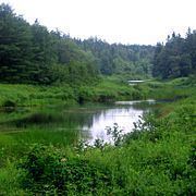
The Kennetcook River is a river that flows through Hants County, Nova Scotia. From headwaters near the mouth of the Shubenacadie River, the Kennetcook traverses about 45 kilometres of mostly rural terrain, discharging into the Avon River at Windsor. The Kennetcook cuts through fossiliferous limestone rocks for part of its length. A tidal river near its mouth, the Kennetcook experiences a tidal bore which may be seen at Scotch Village. It is a known salmon river popular with anglers.
Map of Kennetcook River, West Hants, NS, Canada
The village of Kennetcook takes its name from the river, which is a Mi'kmaq word meaning "the place ahead". It was known to the Acadians as Quenetcou. A covered bridge over the river in Kennetcook was the last in Nova Scotia. It was replaced in 1967.
Nova Scotia Route 236 follows the river for much of the river's length, and the Dominion Atlantic Railway used to parallel the river on its northern side.