
Area 179 km² Local time Saturday 8:49 PM | Website www.keilavald.ee Population 3,995 (1 Jan 2004) | |
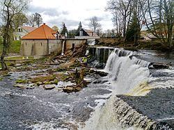 | ||
Weather -2°C, Wind SW at 8 km/h, 94% Humidity Points of interest Keila Waterfall, Keila‑Joa mõis, Kõltsu mõis, Tornimäe juga, Treppoja joastik | ||
Keila Parish (Estonian: Keila vald) is a rural municipality in north-western Estonia. It is a part of Harju County. The municipality has a population of 3,995 (as of 1 January 2004) and covers an area of 178.97 km². The population density is 22.3 inhabitants per km².
Map of Keila, Harju County, Estonia
Local administration of the municipality is located in the town of Keila, although the town itself constitutes separate urban municipality and is not part of Keila Parish. In Keila Parish there are 3 small boroughs (Estonian: alevikud): Karjaküla, Klooga, Keila-Joa and 19 villages (Estonian: külad): Illurma, Käesalu, Keelva, Kersalu, Kloogaranna, Kulna, Laoküla, Laulasmaa, Lehola, Lohusalu, Maeru, Meremõisa, Nahkjala, Niitvälja, Ohtu, Põllküla, Tõmmiku, Tuulna, Valkse.
References
Keila Parish Wikipedia(Text) CC BY-SA