
Country Japan Prefecture Osaka Prefecture Population 112,490 (2010) | Region Kansai Area 109.6 km² Local time Saturday 4:59 PM | |
 | ||
Time zone Japan Standard Time (UTC+9) City hall address 1-1-1, Harachō, Kawachinagano-shi, Ōsaka-fu
586-8501 Website www.city.kawachinagano.lg.jp Weather 8°C, Wind N at 18 km/h, 58% Humidity University Osaka Chiyoda Junior College | ||
Kawachinagano (河内長野市, Kawachinagano-shi) is a city located in Osaka Prefecture, Japan. The city was founded on April 1, 1954. The city is frequently known as Okukawachi.
Contents
- Map of Kawachinagano Osaka Prefecture Japan
- Geography
- Rail
- Bus
- Road
- Temples and Shrines
- Nature and Parks
- Amusement parks
- Schools
- Sister city
- People from Kawachinagano
- References
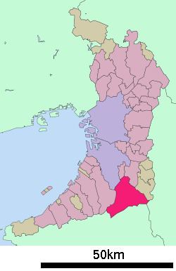
Map of Kawachinagano, Osaka Prefecture, Japan
As of 2010, the city has an estimated population of 112,696 and a population density of 1,030 persons per km². The total area is 109.61 km².
Having a history extending beyond 1,000 years, the city has the 12th most cultural assets in Japan. Much of the city area is within the forest and mountains, and the riches of nature abound in this district.
Geography
Two major rivers flow through the city; the Ishikawa (the larger) and the Amamigawa (the smaller, a tributary of the Yamatogawa). There are mountains such as Mt.Iwawaki and Mt.Kongō in the south and east.
Rail
Kawachinagano Station is the central station of the city.
Bus
Road
Temples and Shrines
Nature and Parks
Amusement parks
Schools
There are 7 junior high schools, 13 elementary schools, 11 kindergartens and 14 day-care centers.